Gingin geodata
Gingin (Western Australia) is a populated place; located in Australia in Australia/Perth (GMT+8) time zone. With population of 806 people, there are 4132 cities with bigger population in this country. Compared to other cities in Australia, 69.9% of cities are located further ↓South; 93.8% of cities are located further →East and 69% of cities have lower elevation than Gingin. Note1


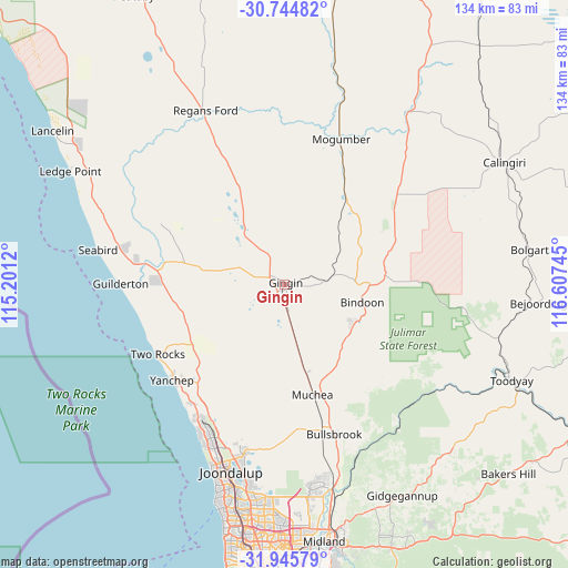
Gingin GPS coordinates[2]
31° 20' 49.992" South, 115° 54' 15.552" East
| Map corner | latitude | longitude |
|---|---|---|
| Upper-left | -30.74482°, | 115.2012° |
| Center: | -31.34722°, | 115.90432° |
| Lower-right: | -31.94579°, | 116.60745° |
| Map W x H: | 133.5×133.5 km | = 83×83mi |
| max Lat: | -10.58257° ⇑30.1% North |
| Gingin: | -31.34722° |
| min Lat: | ⇓69.9% South -43.31423° |
| min Long | Gingin | max Long |
| 113.53327° | 115.90432° | 153.61246° |
| W 6.2%⇐ | ⇒93.8% E |
Elevation
Elevation of Gingin is 96 m = 315 ft, and this is 26 m = 85 ft below average elevation for this country.
| Max E: |
1715 m = 5627 ft | 31% |
| Avg. | 122 m = 400 ft | |
| Gingin | 96 m = 315 ft | |
Min E: |
-2 m = -7 ft | 69% |
See also: Australia elevation on elevation.city.
Geographical zone
Gingin is located in South temperate zone (between Tropic of Capricorn and the Antarctic Circle). Distance of this Southern Tropic circle is 879.6 km =546.6 mi to North.| Distance of | km | miles | from Gingin |
|---|---|---|---|
| Equator | 3485.5 | 2165.8 | to North |
| Tropic Capricorn | 879.6 | 546.6 | to North |
| Antarctic Circle | 3915.7 | 2433.1 | to South |
| South Pole | 6521.6 | 4052.3 | to South |


Nearby cities:
15 places around Gingin: (largest is in red/bold)
• Alkimos
37.7 km =23.4 mi,  213°
213°
• Bindoon
18.8 km =11.7 mi,  103°
103°
• Bullsbrook
36.9 km =22.9 mi,  165°
165°
• Butler
38 km =23.6 mi, 209°
• Chittering
21.4 km =13.3 mi,  128°
128°
• Eglinton
33.6 km =20.9 mi,  217°
217°
• Gabbadah
38.3 km =23.8 mi,  279°
279°
• Jindalee
39 km =24.2 mi, 210°
• Lower Chittering
33.1 km =20.6 mi,  142°
142°
• Muchea
26.9 km =16.7 mi, 166°
• Pearce
37.1 km =23.1 mi,  163°
163°
• Ridgewood
39 km =24.2 mi, 206°
• Two Rocks
34.5 km =21.4 mi,  240°
240°
• Woodridge
29.3 km =18.2 mi,  272°
272°
• Yanchep
34.1 km =21.2 mi,  229°
229°
Sources, notices
• [Note1] Compared only with cities in Australia existing in our database
• [Src1] Map data: © OpenStreetMap contributors (CC-BY-SA)
• [Src2] Other city data from geonames.org with taken over terms of usage.
• [Src3] Geographical zone / Annual Mean Temperature by Robert A. Rohde @ Wikipedia
