Gabbadah geodata
Gabbadah (Western Australia) is a section of populated place; located in Australia in Australia/Perth (GMT+8) time zone. With population of 647 people, there are 4451 cities with bigger population in this country. Compared to other cities in Australia, 70% of cities are located further ↓South; 98.8% of cities are located further →East and 63.7% of cities have higher elevation than Gabbadah. Note1


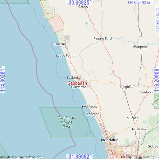
Gabbadah GPS coordinates[2]
31° 17' 31.2" South, 115° 30' 21.348" East
| Map corner | latitude | longitude |
|---|---|---|
| Upper-left | -30.68925°, | 114.80281° |
| Center: | -31.292°, | 115.50593° |
| Lower-right: | -31.89092°, | 116.20906° |
| Map W x H: | 133.6×133.6 km | = 83×83mi |
| max Lat: | -10.58257° ⇑30% North |
| Gabbadah: | -31.292° |
| min Lat: | ⇓70% South -43.31423° |
| min Long | Gabbadah | max Long |
| 113.53327° | 115.50593° | 153.61246° |
| W 1.2%⇐ | ⇒98.8% E |
Elevation
Elevation of Gabbadah is 28 m = 92 ft, and this is 94 m = 308 ft below average elevation for this country.
| Max E: |
1715 m = 5627 ft | 63.7% |
| Avg. | 122 m = 400 ft | |
| Gabbadah | 28 m = 92 ft | |
Min E: |
-2 m = -7 ft | 36.3% |
See also: Australia elevation on elevation.city.
Geographical zone
Gabbadah is located in South temperate zone (between Tropic of Capricorn and the Antarctic Circle). Distance of this Southern Tropic circle is 873.4 km =542.7 mi to North.| Distance of | km | miles | from Gabbadah |
|---|---|---|---|
| Equator | 3479.3 | 2161.9 | to North |
| Tropic Capricorn | 873.4 | 542.7 | to North |
| Antarctic Circle | 3921.8 | 2436.9 | to South |
| South Pole | 6527.7 | 4056.1 | to South |


Nearby cities:
15 places around Gabbadah: (largest is in red/bold)
• Alkimos
41.3 km =25.7 mi,  155°
155°
• Butler
43.3 km =26.9 mi,  154°
154°
• Carramar
50.9 km =31.6 mi, 150°
• Clarkson
48.2 km =30 mi, 154°
• Eglinton
37.1 km =23.1 mi, 152°
• Gingin
38.3 km =23.8 mi,  99°
99°
• Jindalee
43.6 km =27.1 mi, 155°
• Lancelin
34 km =21.1 mi,  331°
331°
• Merriwa
45.9 km =28.5 mi, 154°
• Mindarie
48.1 km =29.9 mi, 156°
• Quinns Rocks
46.4 km =28.8 mi, 156°
• Ridgewood
45.9 km =28.5 mi, 153°
• Two Rocks
24.4 km =15.2 mi, 161°
• Woodridge
9.7 km =6 mi,  118°
118°
• Yanchep
30.7 km =19.1 mi, 157°
Sources, notices
• [Note1] Compared only with cities in Australia existing in our database
• [Src1] Map data: © OpenStreetMap contributors (CC-BY-SA)
• [Src2] Other city data from geonames.org with taken over terms of usage.
• [Src3] Geographical zone / Annual Mean Temperature by Robert A. Rohde @ Wikipedia
