Woombah geodata
Woombah (New South Wales) is a populated place; located in Australia in Australia/Sydney (GMT+11) time zone. With population of 850 people, there are 4062 cities with bigger population in this country. Compared to other cities in Australia, 72.9% of cities are located further ↓South; 97.5% of cities are located further ←West and 99.9% of cities have higher elevation than Woombah. Note1


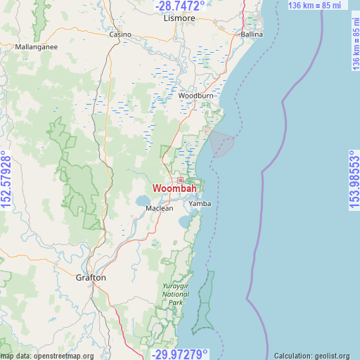
Woombah GPS coordinates[2]
29° 21' 42.624" South, 153° 16' 56.64" East
| Map corner | latitude | longitude |
|---|---|---|
| Upper-left | -28.7472°, | 152.57928° |
| Center: | -29.36184°, | 153.2824° |
| Lower-right: | -29.97279°, | 153.98553° |
| Map W x H: | 136.3×136.3 km | = 84.7×84.7mi |
| max Lat: | -10.58257° ⇑27.1% North |
| Woombah: | -29.36184° |
| min Lat: | ⇓72.9% South -43.31423° |
| min Long | Woombah | max Long |
| 113.53327° | 153.2824° | 153.61246° |
| W 97.5%⇐ | ⇒2.5% E |
Elevation
Elevation of Woombah is 1 m = 3 ft, and this is 121 m = 397 ft below average elevation for this country.
| Max E: |
1715 m = 5627 ft | 99.9% |
| Avg. | 122 m = 400 ft | |
| Woombah | 1 m = 3 ft | |
Min E: |
-2 m = -7 ft | 0.1% |
See also: Australia elevation on elevation.city.
Geographical zone
Woombah is located in South temperate zone (between Tropic of Capricorn and the Antarctic Circle). Distance of this Southern Tropic circle is 658.8 km =409.4 mi to North.| Distance of | km | miles | from Woombah |
|---|---|---|---|
| Equator | 3264.7 | 2028.6 | to North |
| Tropic Capricorn | 658.8 | 409.4 | to North |
| Antarctic Circle | 4136.4 | 2570.2 | to South |
| South Pole | 6742.3 | 4189.5 | to South |


Nearby cities:
15 places around Woombah: (largest is in red/bold)
• Broadwater
41.7 km =25.9 mi,  20°
20°
• Clarenza
46.8 km =29.1 mi,  215°
215°
• Coraki
41.1 km =25.5 mi,  0°
0°
• Evans Head
30.7 km =19.1 mi,  27°
27°
• Gulmarrad
14.7 km =9.1 mi,  198°
198°
• Iluka
8 km =5 mi,  123°
123°
• Junction Hill
46.5 km =28.9 mi,  228°
228°
• Lawrence
23.1 km =14.4 mi, 231°
• Maclean
13.5 km =8.4 mi, 217°
• Palmers Island
6.5 km =4 mi,  174°
174°
• Townsend
13.1 km =8.1 mi,  207°
207°
• Ulmarra
38.7 km =24 mi, 218°
• Wardell
48.9 km =30.4 mi, 20°
• Woodburn
32.9 km =20.4 mi,  10°
10°
• Yamba
11.2 km =7 mi,  138°
138°
Sources, notices
• [Note1] Compared only with cities in Australia existing in our database
• [Src1] Map data: © OpenStreetMap contributors (CC-BY-SA)
• [Src2] Other city data from geonames.org with taken over terms of usage.
• [Src3] Geographical zone / Annual Mean Temperature by Robert A. Rohde @ Wikipedia
