Woodburn geodata
Woodburn (New South Wales) is a populated place; located in Australia in Australia/Sydney (GMT+11) time zone. With population of 715 people, there are 4303 cities with bigger population in this country. Compared to other cities in Australia, 73.1% of cities are located further ↓South; 98% of cities are located further ←West and 95.5% of cities have higher elevation than Woodburn. Note1


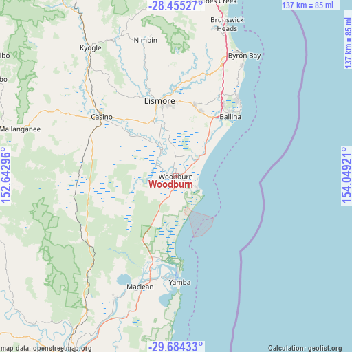
Woodburn GPS coordinates[2]
29° 4' 17.868" South, 153° 20' 45.888" East
| Map corner | latitude | longitude |
|---|---|---|
| Upper-left | -28.45527°, | 152.64296° |
| Center: | -29.07163°, | 153.34608° |
| Lower-right: | -29.68433°, | 154.04921° |
| Map W x H: | 136.7×136.7 km | = 84.9×84.9mi |
| max Lat: | -10.58257° ⇑26.9% North |
| Woodburn: | -29.07163° |
| min Lat: | ⇓73.1% South -43.31423° |
| min Long | Woodburn | max Long |
| 113.53327° | 153.34608° | 153.61246° |
| W 98%⇐ | ⇒2% E |
Elevation
Elevation of Woodburn is 6 m = 20 ft, and this is 116 m = 381 ft below average elevation for this country.
| Max E: |
1715 m = 5627 ft | 95.5% |
| Avg. | 122 m = 400 ft | |
| Woodburn | 6 m = 20 ft | |
Min E: |
-2 m = -7 ft | 4.5% |
See also: Australia elevation on elevation.city.
Geographical zone
Woodburn is located in South temperate zone (between Tropic of Capricorn and the Antarctic Circle). Distance of this Southern Tropic circle is 626.5 km =389.3 mi to North.| Distance of | km | miles | from Woodburn |
|---|---|---|---|
| Equator | 3232.5 | 2008.6 | to North |
| Tropic Capricorn | 626.5 | 389.3 | to North |
| Antarctic Circle | 4168.7 | 2590.3 | to South |
| South Pole | 6774.6 | 4209.5 | to South |


Nearby cities:
15 places around Woodburn: (largest is in red/bold)
• Alstonville
27.1 km =16.8 mi,  19°
19°
• Broadwater
11 km =6.8 mi,  52°
52°
• Caniaba
30.2 km =18.8 mi,  332°
332°
• Coraki
10.7 km =6.6 mi, 325°
• East Lismore
27.9 km =17.3 mi,  348°
348°
• Evans Head
9.7 km =6 mi,  121°
121°
• Girards Hill
29.1 km =18.1 mi, 346°
• Goonellabah
28.5 km =17.7 mi, 354°
• Lismore
29.5 km =18.3 mi, 346°
• Lismore Heights
30.4 km =18.9 mi, 351°
• McLeans Ridges
30.4 km =18.9 mi,  6°
6°
• South Lismore
29.7 km =18.5 mi,  342°
342°
• Wardell
17.5 km =10.9 mi,  40°
40°
• West Ballina
29.6 km =18.4 mi, 37°
• Wollongbar
28.6 km =17.8 mi, 9°
Sources, notices
• [Note1] Compared only with cities in Australia existing in our database
• [Src1] Map data: © OpenStreetMap contributors (CC-BY-SA)
• [Src2] Other city data from geonames.org with taken over terms of usage.
• [Src3] Geographical zone / Annual Mean Temperature by Robert A. Rohde @ Wikipedia
