Broadwater geodata
Broadwater (New South Wales) is a populated place; located in Australia in Australia/Sydney (GMT+11) time zone. With population of 625 people, there are 4504 cities with bigger population in this country. Compared to other cities in Australia, 73.1% of cities are located further ↓South; 99.1% of cities are located further ←West and 98.1% of cities have higher elevation than Broadwater. Note1


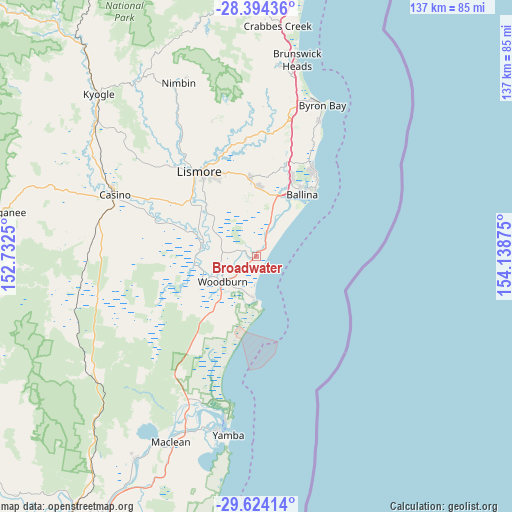
Broadwater GPS coordinates[2]
29° 0' 39.888" South, 153° 26' 8.232" East
| Map corner | latitude | longitude |
|---|---|---|
| Upper-left | -28.39436°, | 152.7325° |
| Center: | -29.01108°, | 153.43562° |
| Lower-right: | -29.62414°, | 154.13875° |
| Map W x H: | 136.7×136.7 km | = 84.9×84.9mi |
| max Lat: | -10.58257° ⇑26.9% North |
| Broadwater: | -29.01108° |
| min Lat: | ⇓73.1% South -43.31423° |
| min Long | Broadwater | max Long |
| 113.53327° | 153.43562° | 153.61246° |
| W 99.1%⇐ | ⇒0.90000000000001% E |
Elevation
Elevation of Broadwater is 4 m = 13 ft, and this is 118 m = 387 ft below average elevation for this country.
| Max E: |
1715 m = 5627 ft | 98.1% |
| Avg. | 122 m = 400 ft | |
| Broadwater | 4 m = 13 ft | |
Min E: |
-2 m = -7 ft | 1.9% |
See also: Australia elevation on elevation.city.
Geographical zone
Broadwater is located in South temperate zone (between Tropic of Capricorn and the Antarctic Circle). Distance of this Southern Tropic circle is 619.8 km =385.1 mi to North.| Distance of | km | miles | from Broadwater |
|---|---|---|---|
| Equator | 3225.7 | 2004.4 | to North |
| Tropic Capricorn | 619.8 | 385.1 | to North |
| Antarctic Circle | 4175.4 | 2594.5 | to South |
| South Pole | 6781.3 | 4213.7 | to South |


Nearby cities:
15 places around Broadwater: (largest is in red/bold)
• Alstonville
18.8 km =11.7 mi,  1°
1°
• Ballina
20.7 km =12.9 mi,  37°
37°
• Coraki
14.9 km =9.3 mi,  277°
277°
• Cumbalum
22.8 km =14.2 mi,  23°
23°
• East Ballina
22.6 km =14 mi, 40°
• East Lismore
25.1 km =15.6 mi,  325°
325°
• Evans Head
11.9 km =7.4 mi,  182°
182°
• Goonellabah
24.5 km =15.2 mi, 331°
• McLeans Ridges
24 km =14.9 mi,  347°
347°
• Skennars Head
25.9 km =16.1 mi, 38°
• Tintenbar
25.1 km =15.6 mi, 19°
• Wardell
7.1 km =4.4 mi, 20°
• West Ballina
19.1 km =11.9 mi,  29°
29°
• Wollongbar
21.8 km =13.5 mi, 350°
• Woodburn
11 km =6.8 mi,  232°
232°
Sources, notices
• [Note1] Compared only with cities in Australia existing in our database
• [Src1] Map data: © OpenStreetMap contributors (CC-BY-SA)
• [Src2] Other city data from geonames.org with taken over terms of usage.
• [Src3] Geographical zone / Annual Mean Temperature by Robert A. Rohde @ Wikipedia
