Willow Grove geodata
Willow Grove (Victoria) is a populated place; located in Australia in Australia/Melbourne (GMT+11) time zone. With population of 567 people, there are 4658 cities with bigger population in this country. Compared to other cities in Australia, 92.6% of cities are located further ↑North; 56.4% of cities are located further →East and 80.2% of cities have lower elevation than Willow Grove. Note1


Willow Grove GPS coordinates[2]
38° 4' 59.988" South, 146° 12' 0" East
| Map corner | latitude | longitude |
|---|---|---|
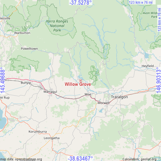
| Upper-left | -37.5278°, | 145.49688° |
| Center: | -38.08333°, | 146.2° |
| Lower-right: | -38.63467°, | 146.90313° |
| Map W x H: | 123.1×123.1 km | = 76.5×76.5mi |
| max Lat: | -10.58257° ⇑92.6% North |
| Willow Grove: | -38.08333° |
| min Lat: | ⇓7.4% South -43.31423° |
| min Long | Willow Grove | max Long |
| 113.53327° | 146.2° | 153.61246° |
| W 43.6%⇐ | ⇒56.4% E |
Elevation
Elevation of Willow Grove is 184 m = 604 ft, and this is 62 m = 203 ft above average elevation for this country.
| Max E: |
1715 m = 5627 ft | 19.8% |
| Willow Grove | 184 m 604 ft | |
| Avg. | 122 m = 400 ft | |
Min E: |
-2 m = -7 ft | 80.2% |
See also: Australia elevation on elevation.city.
Geographical zone
Willow Grove is located in South temperate zone (between Tropic of Capricorn and the Antarctic Circle). Distance of this Southern Tropic circle is 1628.6 km =1012 mi to North.| Distance of | km | miles | from Willow Grove |
|---|---|---|---|
| Equator | 4234.5 | 2631.2 | to North |
| Tropic Capricorn | 1628.6 | 1012 | to North |
| Antarctic Circle | 3166.7 | 1967.7 | to South |
| South Pole | 5772.6 | 3586.9 | to South |


Nearby cities:
15 places around Willow Grove: (largest is in red/bold)
• Buln Buln
23.4 km =14.5 mi,  265°
265°
• Darnum
20.7 km =12.9 mi,  235°
235°
• Drouin
30.5 km =19 mi,  258°
258°
• Moe
11.8 km =7.3 mi,  153°
153°
• Moe South
15.1 km =9.4 mi,  162°
162°
• Morwell
24 km =14.9 mi,  134°
134°
• Neerim South
22.7 km =14.1 mi,  288°
288°
• Newborough
12.7 km =7.9 mi,  140°
140°
• Tanjil South
5.7 km =3.5 mi, 130°
• Trafalgar
14.6 km =9.1 mi,  196°
196°
• Tyers
25.6 km =15.9 mi,  106°
106°
• Warragul
25 km =15.5 mi,  250°
250°
• Yallourn North
16.8 km =10.4 mi,  120°
120°
• Yarragon
18.2 km =11.3 mi,  221°
221°
• Yinnar
28.9 km =18 mi, 156°
Sources, notices
• [Note1] Compared only with cities in Australia existing in our database
• [Src1] Map data: © OpenStreetMap contributors (CC-BY-SA)
• [Src2] Other city data from geonames.org with taken over terms of usage.
• [Src3] Geographical zone / Annual Mean Temperature by Robert A. Rohde @ Wikipedia
