Neerim South geodata
Neerim South (Victoria) is a populated place; located in Australia in Australia/Melbourne (GMT+11) time zone. With population of 1,271 people, there are 3502 cities with bigger population in this country. Compared to other cities in Australia, 91.9% of cities are located further ↑North; 57.2% of cities are located further →East and 85.6% of cities have lower elevation than Neerim South. Note1


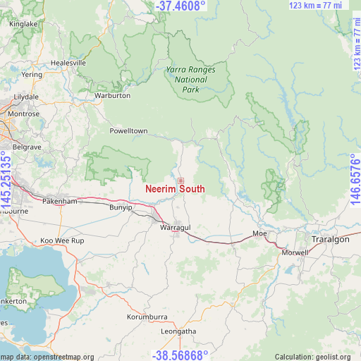
Neerim South GPS coordinates[2]
38° 1' 0.588" South, 145° 57' 16.092" East
| Map corner | latitude | longitude |
|---|---|---|
| Upper-left | -37.4608°, | 145.25135° |
| Center: | -38.01683°, | 145.95447° |
| Lower-right: | -38.56868°, | 146.6576° |
| Map W x H: | 123.2×123.2 km | = 76.6×76.6mi |
| max Lat: | -10.58257° ⇑91.9% North |
| Neerim South: | -38.01683° |
| min Lat: | ⇓8.1% South -43.31423° |
| min Long | Neerim South | max Long |
| 113.53327° | 145.95447° | 153.61246° |
| W 42.8%⇐ | ⇒57.2% E |
Elevation
Elevation of Neerim South is 258 m = 846 ft, and this is 136 m = 446 ft above average elevation for this country.
| Max E: |
1715 m = 5627 ft | 14.4% |
| Neerim South | 258 m 846 ft | |
| Avg. | 122 m = 400 ft | |
Min E: |
-2 m = -7 ft | 85.6% |
See also: Australia elevation on elevation.city.
Geographical zone
Neerim South is located in South temperate zone (between Tropic of Capricorn and the Antarctic Circle). Distance of this Southern Tropic circle is 1621.2 km =1007.4 mi to North.| Distance of | km | miles | from Neerim South |
|---|---|---|---|
| Equator | 4227.1 | 2626.6 | to North |
| Tropic Capricorn | 1621.2 | 1007.4 | to North |
| Antarctic Circle | 3174.1 | 1972.3 | to South |
| South Pole | 5780 | 3591.5 | to South |


Nearby cities:
15 places around Neerim South: (largest is in red/bold)
• Buln Buln
9.4 km =5.8 mi,  191°
191°
• Bunyip
22.7 km =14.1 mi,  246°
246°
• Darnum
19.6 km =12.2 mi,  166°
166°
• Drouin
15.7 km =9.8 mi,  212°
212°
• Garfield
25.8 km =16 mi, 251°
• Longwarry
19.5 km =12.1 mi,  236°
236°
• Maryknoll
31.6 km =19.6 mi,  266°
266°
• Moe
32.3 km =20.1 mi,  123°
123°
• Moe South
34 km =21.1 mi,  129°
129°
• Nar Nar Goon North
34 km =21.1 mi, 270°
• Tanjil South
28.2 km =17.5 mi,  113°
113°
• Trafalgar
27.6 km =17.1 mi,  140°
140°
• Warragul
16 km =9.9 mi, 187°
• Willow Grove
22.7 km =14.1 mi, 108°
• Yarragon
22.9 km =14.2 mi,  156°
156°
Sources, notices
• [Note1] Compared only with cities in Australia existing in our database
• [Src1] Map data: © OpenStreetMap contributors (CC-BY-SA)
• [Src2] Other city data from geonames.org with taken over terms of usage.
• [Src3] Geographical zone / Annual Mean Temperature by Robert A. Rohde @ Wikipedia
