Tanjil South geodata
Tanjil South (Victoria) is a populated place; located in Australia in Australia/Melbourne (GMT+11) time zone. With population of 513 people, there are 4842 cities with bigger population in this country. Compared to other cities in Australia, 93% of cities are located further ↑North; 56.3% of cities are located further →East and 70% of cities have lower elevation than Tanjil South. Note1


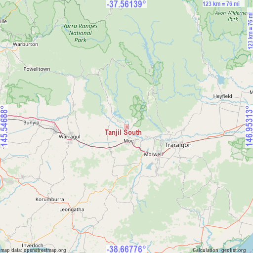
Tanjil South GPS coordinates[2]
38° 7' 0.012" South, 146° 15' 0" East
| Map corner | latitude | longitude |
|---|---|---|
| Upper-left | -37.56139°, | 145.54688° |
| Center: | -38.11667°, | 146.25° |
| Lower-right: | -38.66776°, | 146.95313° |
| Map W x H: | 123×123 km | = 76.4×76.4mi |
| max Lat: | -10.58257° ⇑93% North |
| Tanjil South: | -38.11667° |
| min Lat: | ⇓7% South -43.31423° |
| min Long | Tanjil South | max Long |
| 113.53327° | 146.25° | 153.61246° |
| W 43.7%⇐ | ⇒56.3% E |
Elevation
Elevation of Tanjil South is 103 m = 338 ft, and this is 19 m = 62 ft below average elevation for this country.
| Max E: |
1715 m = 5627 ft | 30% |
| Avg. | 122 m = 400 ft | |
| Tanjil South | 103 m = 338 ft | |
Min E: |
-2 m = -7 ft | 70% |
See also: Australia elevation on elevation.city.
Geographical zone
Tanjil South is located in South temperate zone (between Tropic of Capricorn and the Antarctic Circle). Distance of this Southern Tropic circle is 1632.3 km =1014.3 mi to North.| Distance of | km | miles | from Tanjil South |
|---|---|---|---|
| Equator | 4238.2 | 2633.5 | to North |
| Tropic Capricorn | 1632.3 | 1014.3 | to North |
| Antarctic Circle | 3163 | 1965.4 | to South |
| South Pole | 5768.9 | 3584.6 | to South |


Nearby cities:
15 places around Tanjil South: (largest is in red/bold)
• Churchill
25.6 km =15.9 mi,  146°
146°
• Darnum
22.8 km =14.2 mi,  249°
249°
• Glengarry
27.7 km =17.2 mi,  90°
90°
• Hazelwood North
26.4 km =16.4 mi,  129°
129°
• Moe
6.9 km =4.3 mi,  172°
172°
• Moe South
10.7 km =6.6 mi,  178°
178°
• Morwell
18.2 km =11.3 mi,  136°
136°
• Newborough
7.2 km =4.5 mi, 148°
• Trafalgar
13.3 km =8.3 mi,  219°
219°
• Traralgon
26.9 km =16.7 mi,  108°
108°
• Tyers
20.5 km =12.7 mi,  100°
100°
• Willow Grove
5.7 km =3.5 mi,  310°
310°
• Yallourn North
11.1 km =6.9 mi,  115°
115°
• Yarragon
19.3 km =12 mi,  239°
239°
• Yinnar
23.9 km =14.9 mi,  163°
163°
Sources, notices
• [Note1] Compared only with cities in Australia existing in our database
• [Src1] Map data: © OpenStreetMap contributors (CC-BY-SA)
• [Src2] Other city data from geonames.org with taken over terms of usage.
• [Src3] Geographical zone / Annual Mean Temperature by Robert A. Rohde @ Wikipedia
