Walla Walla geodata
Walla Walla (New South Wales) is a populated place; located in Australia in Australia/Sydney (GMT+11) time zone. With population of 862 people, there are 4037 cities with bigger population in this country. Compared to other cities in Australia, 77.8% of cities are located further ↑North; 53.7% of cities are located further →East and 82.6% of cities have lower elevation than Walla Walla. Note1


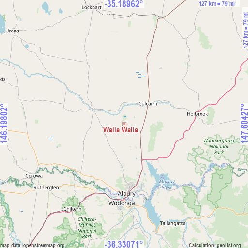
Walla Walla GPS coordinates[2]
35° 45' 43.956" South, 146° 54' 4.104" East
| Map corner | latitude | longitude |
|---|---|---|
| Upper-left | -35.18962°, | 146.19802° |
| Center: | -35.76221°, | 146.90114° |
| Lower-right: | -36.33071°, | 147.60427° |
| Map W x H: | 126.9×126.9 km | = 78.9×78.9mi |
| max Lat: | -10.58257° ⇑77.8% North |
| Walla Walla: | -35.76221° |
| min Lat: | ⇓22.2% South -43.31423° |
| min Long | Walla Walla | max Long |
| 113.53327° | 146.90114° | 153.61246° |
| W 46.3%⇐ | ⇒53.7% E |
Elevation
Elevation of Walla Walla is 213 m = 699 ft, and this is 91 m = 299 ft above average elevation for this country.
| Max E: |
1715 m = 5627 ft | 17.4% |
| Walla Walla | 213 m 699 ft | |
| Avg. | 122 m = 400 ft | |
Min E: |
-2 m = -7 ft | 82.6% |
See also: Australia elevation on elevation.city.
Geographical zone
Walla Walla is located in South temperate zone (between Tropic of Capricorn and the Antarctic Circle). Distance of this Southern Tropic circle is 1370.5 km =851.6 mi to North.| Distance of | km | miles | from Walla Walla |
|---|---|---|---|
| Equator | 3976.4 | 2470.8 | to North |
| Tropic Capricorn | 1370.5 | 851.6 | to North |
| Antarctic Circle | 3424.8 | 2128.1 | to South |
| South Pole | 6030.7 | 3747.3 | to South |


Nearby cities:
15 places around Walla Walla: (largest is in red/bold)
• Albury
34.8 km =21.6 mi,  176°
176°
• Culcairn
16.3 km =10.1 mi,  49°
49°
• East Albury
35.6 km =22.1 mi, 175°
• Gerogery
11.5 km =7.1 mi,  134°
134°
• Glenroy
32 km =19.9 mi, 178°
• Hamilton Valley
30.7 km =19.1 mi, 177°
• Henty
29.4 km =18.3 mi,  24°
24°
• Howlong
34.4 km =21.4 mi,  224°
224°
• Jindera
21.4 km =13.3 mi, 183°
• Lavington
31.1 km =19.3 mi,  173°
173°
• North Albury
32.9 km =20.4 mi, 175°
• Springdale Heights
30.2 km =18.8 mi, 171°
• Table Top
24.4 km =15.2 mi,  158°
158°
• Thurgoona
31.6 km =19.6 mi, 164°
• West Albury
35.3 km =21.9 mi, 181°
Sources, notices
• [Note1] Compared only with cities in Australia existing in our database
• [Src1] Map data: © OpenStreetMap contributors (CC-BY-SA)
• [Src2] Other city data from geonames.org with taken over terms of usage.
• [Src3] Geographical zone / Annual Mean Temperature by Robert A. Rohde @ Wikipedia
