Howlong geodata
Howlong (New South Wales) is a populated place; located in Australia in Australia/Sydney (GMT+11) time zone. With population of 2,695 people, there are 2437 cities with bigger population in this country. Compared to other cities in Australia, 78.3% of cities are located further ↑North; 55% of cities are located further →East and 77% of cities have lower elevation than Howlong. Note1


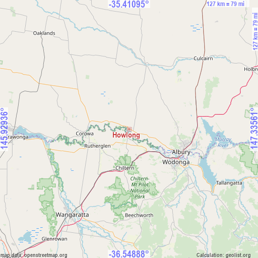
Howlong GPS coordinates[2]
35° 58' 55.092" South, 146° 37' 56.928" East
| Map corner | latitude | longitude |
|---|---|---|
| Upper-left | -35.41095°, | 145.92936° |
| Center: | -35.98197°, | 146.63248° |
| Lower-right: | -36.54888°, | 147.33561° |
| Map W x H: | 126.5×126.5 km | = 78.6×78.6mi |
| max Lat: | -10.58257° ⇑78.3% North |
| Howlong: | -35.98197° |
| min Lat: | ⇓21.7% South -43.31423° |
| min Long | Howlong | max Long |
| 113.53327° | 146.63248° | 153.61246° |
| W 45%⇐ | ⇒55% E |
Elevation
Elevation of Howlong is 148 m = 486 ft, and this is 26 m = 85 ft above average elevation for this country.
| Max E: |
1715 m = 5627 ft | 23% |
| Howlong | 148 m 486 ft | |
| Avg. | 122 m = 400 ft | |
Min E: |
-2 m = -7 ft | 77% |
See also: Australia elevation on elevation.city.
Geographical zone
Howlong is located in South temperate zone (between Tropic of Capricorn and the Antarctic Circle). Distance of this Southern Tropic circle is 1394.9 km =866.8 mi to North.| Distance of | km | miles | from Howlong |
|---|---|---|---|
| Equator | 4000.8 | 2486 | to North |
| Tropic Capricorn | 1394.9 | 866.8 | to North |
| Antarctic Circle | 3400.4 | 2112.9 | to South |
| South Pole | 6006.2 | 3732.1 | to South |


Nearby cities:
15 places around Howlong: (largest is in red/bold)
• Albury
28.2 km =17.5 mi,  111°
111°
• Barnawartha
14.1 km =8.8 mi,  163°
163°
• Chiltern
18.9 km =11.7 mi,  186°
186°
• Corowa
22.3 km =13.9 mi,  265°
265°
• Glenroy
26.1 km =16.2 mi, 106°
• Hamilton Valley
26.4 km =16.4 mi,  103°
103°
• Jindera
23.2 km =14.4 mi,  82°
82°
• Lavington
28.4 km =17.6 mi, 103°
• North Albury
28 km =17.4 mi, 107°
• Rutherglen
17.3 km =10.7 mi,  242°
242°
• South Albury
27.5 km =17.1 mi,  115°
115°
• Wahgunyah
21.4 km =13.3 mi,  261°
261°
• West Albury
25.8 km =16 mi, 114°
• West Wodonga
25.2 km =15.7 mi,  128°
128°
• Wodonga
27.7 km =17.2 mi, 124°
Sources, notices
• [Note1] Compared only with cities in Australia existing in our database
• [Src1] Map data: © OpenStreetMap contributors (CC-BY-SA)
• [Src2] Other city data from geonames.org with taken over terms of usage.
• [Src3] Geographical zone / Annual Mean Temperature by Robert A. Rohde @ Wikipedia
