Toora geodata
Toora (Victoria) is a populated place; located in Australia in Australia/Melbourne (GMT+11) time zone. With population of 661 people, there are 4404 cities with bigger population in this country. Compared to other cities in Australia, 96.2% of cities are located further ↑North; 56% of cities are located further →East and 54.5% of cities have higher elevation than Toora. Note1


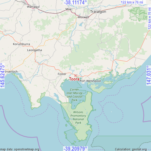
Toora GPS coordinates[2]
38° 39' 46.332" South, 146° 19' 40.332" East
| Map corner | latitude | longitude |
|---|---|---|
| Upper-left | -38.11174°, | 145.62475° |
| Center: | -38.66287°, | 146.32787° |
| Lower-right: | -39.20979°, | 147.031° |
| Map W x H: | 122.1×122.1 km | = 75.9×75.9mi |
| max Lat: | -10.58257° ⇑96.2% North |
| Toora: | -38.66287° |
| min Lat: | ⇓3.8% South -43.31423° |
| min Long | Toora | max Long |
| 113.53327° | 146.32787° | 153.61246° |
| W 44%⇐ | ⇒56% E |
Elevation
Elevation of Toora is 39 m = 128 ft, and this is 83 m = 272 ft below average elevation for this country.
| Max E: |
1715 m = 5627 ft | 54.5% |
| Avg. | 122 m = 400 ft | |
| Toora | 39 m = 128 ft | |
Min E: |
-2 m = -7 ft | 45.5% |
See also: Australia elevation on elevation.city.
Geographical zone
Toora is located in South temperate zone (between Tropic of Capricorn and the Antarctic Circle). Distance of this Southern Tropic circle is 1693 km =1052 mi to North.| Distance of | km | miles | from Toora |
|---|---|---|---|
| Equator | 4298.9 | 2671.2 | to North |
| Tropic Capricorn | 1693 | 1052 | to North |
| Antarctic Circle | 3102.3 | 1927.7 | to South |
| South Pole | 5708.2 | 3546.9 | to South |


Nearby cities:
15 places around Toora: (largest is in red/bold)
• Boolarra
31.9 km =19.8 mi,  351°
351°
• Churchill
40.2 km =25 mi,  10°
10°
• Fish Creek
21.3 km =13.2 mi,  263°
263°
• Foster
11.1 km =6.9 mi,  275°
275°
• Hazelwood North
46 km =28.6 mi,  17°
17°
• Jeeralang Junction
35.8 km =22.2 mi, 11°
• Leongatha
39.1 km =24.3 mi,  302°
302°
• Meeniyan
28.5 km =17.7 mi,  289°
289°
• Mirboo North
32.5 km =20.2 mi,  333°
333°
• Morwell
48 km =29.8 mi, 7°
• Traralgon South
45.6 km =28.3 mi, 24°
• Venus Bay
44.1 km =27.4 mi, 264°
• Yarram
32.1 km =19.9 mi,  70°
70°
• Yinnar
37.8 km =23.5 mi,  0°
0°
• Yinnar South
31.5 km =19.6 mi, 8°
Sources, notices
• [Note1] Compared only with cities in Australia existing in our database
• [Src1] Map data: © OpenStreetMap contributors (CC-BY-SA)
• [Src2] Other city data from geonames.org with taken over terms of usage.
• [Src3] Geographical zone / Annual Mean Temperature by Robert A. Rohde @ Wikipedia
