Venus Bay geodata
Venus Bay (Victoria) is a populated place; located in Australia in Australia/Melbourne (GMT+11) time zone. With population of 999 people, there are 3819 cities with bigger population in this country. Compared to other cities in Australia, 96.2% of cities are located further ↑North; 57.8% of cities are located further →East and 83.5% of cities have higher elevation than Venus Bay. Note1


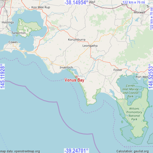
Venus Bay GPS coordinates[2]
38° 42' 1.368" South, 145° 49' 20.64" East
| Map corner | latitude | longitude |
|---|---|---|
| Upper-left | -38.14954°, | 145.11928° |
| Center: | -38.70038°, | 145.8224° |
| Lower-right: | -39.24701°, | 146.52553° |
| Map W x H: | 122×122 km | = 75.8×75.8mi |
| max Lat: | -10.58257° ⇑96.2% North |
| Venus Bay: | -38.70038° |
| min Lat: | ⇓3.8% South -43.31423° |
| min Long | Venus Bay | max Long |
| 113.53327° | 145.8224° | 153.61246° |
| W 42.2%⇐ | ⇒57.8% E |
Elevation
Elevation of Venus Bay is 13 m = 43 ft, and this is 109 m = 358 ft below average elevation for this country.
| Max E: |
1715 m = 5627 ft | 83.5% |
| Avg. | 122 m = 400 ft | |
| Venus Bay | 13 m = 43 ft | |
Min E: |
-2 m = -7 ft | 16.5% |
See also: Australia elevation on elevation.city.
Geographical zone
Venus Bay is located in South temperate zone (between Tropic of Capricorn and the Antarctic Circle). Distance of this Southern Tropic circle is 1697.2 km =1054.6 mi to North.| Distance of | km | miles | from Venus Bay |
|---|---|---|---|
| Equator | 4303.1 | 2673.8 | to North |
| Tropic Capricorn | 1697.2 | 1054.6 | to North |
| Antarctic Circle | 3098.1 | 1925.1 | to South |
| South Pole | 5704 | 3544.3 | to South |


Nearby cities:
15 places around Venus Bay: (largest is in red/bold)
• Cape Paterson
17.8 km =11.1 mi,  280°
280°
• Dalyston
27.9 km =17.3 mi,  302°
302°
• Fish Creek
22.7 km =14.1 mi,  85°
85°
• Foster
33.3 km =20.7 mi,  80°
80°
• Grantville
41.3 km =25.7 mi,  322°
322°
• Inverloch
11.9 km =7.4 mi,  313°
313°
• Korumburra
29.8 km =18.5 mi,  0°
0°
• Leongatha
27.2 km =16.9 mi,  23°
23°
• Loch
38.2 km =23.7 mi,  344°
344°
• Meeniyan
21.9 km =13.6 mi,  51°
51°
• North Wonthaggi
24.1 km =15 mi, 304°
• Nyora
42.8 km =26.6 mi, 342°
• Poowong
40.1 km =24.9 mi,  352°
352°
• San Remo
43.4 km =27 mi, 296°
• Wonthaggi
22.5 km =14 mi, 297°
Sources, notices
• [Note1] Compared only with cities in Australia existing in our database
• [Src1] Map data: © OpenStreetMap contributors (CC-BY-SA)
• [Src2] Other city data from geonames.org with taken over terms of usage.
• [Src3] Geographical zone / Annual Mean Temperature by Robert A. Rohde @ Wikipedia
