Foster geodata
Foster (Victoria) is a populated place; located in Australia in Australia/Melbourne (GMT+11) time zone. With population of 1,740 people, there are 3084 cities with bigger population in this country. Compared to other cities in Australia, 96.1% of cities are located further ↑North; 56.4% of cities are located further →East and 54.5% of cities have higher elevation than Foster. Note1


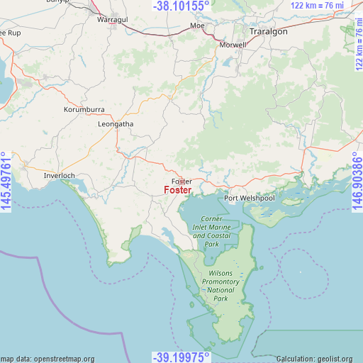
Foster GPS coordinates[2]
38° 39' 9.9" South, 146° 12' 2.628" East
| Map corner | latitude | longitude |
|---|---|---|
| Upper-left | -38.10155°, | 145.49761° |
| Center: | -38.65275°, | 146.20073° |
| Lower-right: | -39.19975°, | 146.90386° |
| Map W x H: | 122.1×122.1 km | = 75.9×75.9mi |
| max Lat: | -10.58257° ⇑96.1% North |
| Foster: | -38.65275° |
| min Lat: | ⇓3.9% South -43.31423° |
| min Long | Foster | max Long |
| 113.53327° | 146.20073° | 153.61246° |
| W 43.6%⇐ | ⇒56.4% E |
Elevation
Elevation of Foster is 39 m = 128 ft, and this is 83 m = 272 ft below average elevation for this country.
| Max E: |
1715 m = 5627 ft | 54.5% |
| Avg. | 122 m = 400 ft | |
| Foster | 39 m = 128 ft | |
Min E: |
-2 m = -7 ft | 45.5% |
See also: Australia elevation on elevation.city.
Geographical zone
Foster is located in South temperate zone (between Tropic of Capricorn and the Antarctic Circle). Distance of this Southern Tropic circle is 1691.9 km =1051.3 mi to North.| Distance of | km | miles | from Foster |
|---|---|---|---|
| Equator | 4297.8 | 2670.5 | to North |
| Tropic Capricorn | 1691.9 | 1051.3 | to North |
| Antarctic Circle | 3103.4 | 1928.4 | to South |
| South Pole | 5709.3 | 3547.6 | to South |


Nearby cities:
15 places around Foster: (largest is in red/bold)
• Boolarra
31.1 km =19.3 mi,  12°
12°
• Churchill
42.6 km =26.5 mi,  25°
25°
• Fish Creek
10.7 km =6.6 mi,  251°
251°
• Inverloch
41.6 km =25.8 mi,  274°
274°
• Jeeralang Junction
38.6 km =24 mi, 28°
• Korumburra
41 km =25.5 mi,  306°
306°
• Leongatha
29.5 km =18.3 mi, 311°
• Meeniyan
17.9 km =11.1 mi,  298°
298°
• Mirboo North
28.2 km =17.5 mi,  353°
353°
• Moe South
49.1 km =30.5 mi, 5°
• Toora
11.1 km =6.9 mi,  95°
95°
• Venus Bay
33.3 km =20.7 mi,  260°
260°
• Yarram
42.4 km =26.3 mi,  76°
76°
• Yinnar
38.4 km =23.9 mi,  16°
16°
• Yinnar South
33.9 km =21.1 mi, 27°
Sources, notices
• [Note1] Compared only with cities in Australia existing in our database
• [Src1] Map data: © OpenStreetMap contributors (CC-BY-SA)
• [Src2] Other city data from geonames.org with taken over terms of usage.
• [Src3] Geographical zone / Annual Mean Temperature by Robert A. Rohde @ Wikipedia
