Toongabbie geodata
Toongabbie (Victoria) is a populated place; located in Australia in Australia/Melbourne (GMT+11) time zone. With population of 976 people, there are 3861 cities with bigger population in this country. Compared to other cities in Australia, 92.3% of cities are located further ↑North; 55.1% of cities are located further →East and 66.8% of cities have lower elevation than Toongabbie. Note1


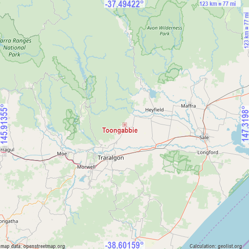
Toongabbie GPS coordinates[2]
38° 3' 0" South, 146° 37' 0.012" East
| Map corner | latitude | longitude |
|---|---|---|
| Upper-left | -37.49422°, | 145.91355° |
| Center: | -38.05°, | 146.61667° |
| Lower-right: | -38.60159°, | 147.3198° |
| Map W x H: | 123.1×123.1 km | = 76.5×76.5mi |
| max Lat: | -10.58257° ⇑92.3% North |
| Toongabbie: | -38.05° |
| min Lat: | ⇓7.7% South -43.31423° |
| min Long | Toongabbie | max Long |
| 113.53327° | 146.61667° | 153.61246° |
| W 44.9%⇐ | ⇒55.1% E |
Elevation
Elevation of Toongabbie is 87 m = 285 ft, and this is 35 m = 115 ft below average elevation for this country.
| Max E: |
1715 m = 5627 ft | 33.2% |
| Avg. | 122 m = 400 ft | |
| Toongabbie | 87 m = 285 ft | |
Min E: |
-2 m = -7 ft | 66.8% |
See also: Australia elevation on elevation.city.
Geographical zone
Toongabbie is located in South temperate zone (between Tropic of Capricorn and the Antarctic Circle). Distance of this Southern Tropic circle is 1624.8 km =1009.6 mi to North.| Distance of | km | miles | from Toongabbie |
|---|---|---|---|
| Equator | 4230.8 | 2628.9 | to North |
| Tropic Capricorn | 1624.8 | 1009.6 | to North |
| Antarctic Circle | 3170.4 | 1970 | to South |
| South Pole | 5776.3 | 3589.2 | to South |


Nearby cities:
15 places around Toongabbie: (largest is in red/bold)
• Churchill
33.7 km =20.9 mi,  211°
211°
• Fulham
32.6 km =20.3 mi,  99°
99°
• Glengarry
8.6 km =5.3 mi, 210°
• Hazelwood North
26.9 km =16.7 mi, 205°
• Heyfield
16.7 km =10.4 mi,  62°
62°
• Maffra
33.3 km =20.7 mi,  74°
74°
• Moe
34.2 km =21.3 mi,  245°
245°
• Morwell
28.2 km =17.5 mi,  223°
223°
• Newborough
31.4 km =19.5 mi,  244°
244°
• Rosedale
19 km =11.8 mi,  127°
127°
• Tanjil South
32.9 km =20.4 mi,  256°
256°
• Traralgon
17.4 km =10.8 mi,  202°
202°
• Traralgon South
27.4 km =17 mi,  193°
193°
• Tyers
16.2 km =10.1 mi,  227°
227°
• Yallourn North
25.3 km =15.7 mi, 240°
Sources, notices
• [Note1] Compared only with cities in Australia existing in our database
• [Src1] Map data: © OpenStreetMap contributors (CC-BY-SA)
• [Src2] Other city data from geonames.org with taken over terms of usage.
• [Src3] Geographical zone / Annual Mean Temperature by Robert A. Rohde @ Wikipedia
