Toogoolawah geodata
Toogoolawah (Queensland) is a populated place; located in Australia in Australia/Brisbane (GMT+10) time zone. With population of 1,301 people, there are 3476 cities with bigger population in this country. Compared to other cities in Australia, 85.4% of cities are located further ↓South; 83.9% of cities are located further ←West and 70.4% of cities have lower elevation than Toogoolawah. Note1


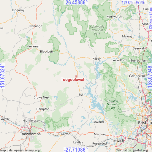
Toogoolawah GPS coordinates[2]
27° 5' 11.796" South, 152° 22' 34.896" East
| Map corner | latitude | longitude |
|---|---|---|
| Upper-left | -26.45886°, | 151.67324° |
| Center: | -27.08661°, | 152.37636° |
| Lower-right: | -27.71086°, | 153.07949° |
| Map W x H: | 139.2×139.2 km | = 86.5×86.5mi |
| max Lat: | -10.58257° ⇑14.6% North |
| Toogoolawah: | -27.08661° |
| min Lat: | ⇓85.4% South -43.31423° |
| min Long | Toogoolawah | max Long |
| 113.53327° | 152.37636° | 153.61246° |
| W 83.9%⇐ | ⇒16.1% E |
Elevation
Elevation of Toogoolawah is 105 m = 344 ft, and this is 17 m = 56 ft below average elevation for this country.
| Max E: |
1715 m = 5627 ft | 29.6% |
| Avg. | 122 m = 400 ft | |
| Toogoolawah | 105 m = 344 ft | |
Min E: |
-2 m = -7 ft | 70.4% |
See also: Australia elevation on elevation.city.
Geographical zone
Toogoolawah is located in South temperate zone (between Tropic of Capricorn and the Antarctic Circle). Distance of this Southern Tropic circle is 405.8 km =252.2 mi to North.| Distance of | km | miles | from Toogoolawah |
|---|---|---|---|
| Equator | 3011.7 | 1871.4 | to North |
| Tropic Capricorn | 405.8 | 252.2 | to North |
| Antarctic Circle | 4389.4 | 2727.4 | to South |
| South Pole | 6995.3 | 4346.7 | to South |


Nearby cities:
15 places around Toogoolawah: (largest is in red/bold)
• Blackbutt
35.2 km =21.9 mi,  309°
309°
• Coominya
35.9 km =22.3 mi,  159°
159°
• Crows Nest
37.5 km =23.3 mi,  239°
239°
• Dayboro
45.8 km =28.5 mi,  105°
105°
• Delaneys Creek
42.6 km =26.5 mi,  76°
76°
• D’Aguilar
43.5 km =27 mi,  74°
74°
• Esk
17.5 km =10.9 mi,  165°
165°
• Kilcoy
24.6 km =15.3 mi,  49°
49°
• Lockrose
45.5 km =28.3 mi, 169°
• Lockyer Waters
40.9 km =25.4 mi,  175°
175°
• Lowood
46.5 km =28.9 mi,  154°
154°
• Ocean View
42.7 km =26.5 mi,  96°
96°
• Sandy Creek
36.9 km =22.9 mi,  44°
44°
• Spring Creek
41 km =25.5 mi,  186°
186°
• Woodford
42.4 km =26.3 mi, 69°
Sources, notices
• [Note1] Compared only with cities in Australia existing in our database
• [Src1] Map data: © OpenStreetMap contributors (CC-BY-SA)
• [Src2] Other city data from geonames.org with taken over terms of usage.
• [Src3] Geographical zone / Annual Mean Temperature by Robert A. Rohde @ Wikipedia
