Crows Nest geodata
Crows Nest (Queensland) is a populated place; located in Australia in Australia/Brisbane (GMT+10) time zone. With population of 2,160 people, there are 2788 cities with bigger population in this country. Compared to other cities in Australia, 84.8% of cities are located further ↓South; 82.9% of cities are located further ←West and 94.2% of cities have lower elevation than Crows Nest. Note1


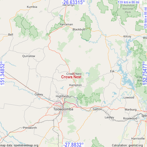
Crows Nest GPS coordinates[2]
27° 15' 35.748" South, 152° 3' 5.904" East
| Map corner | latitude | longitude |
|---|---|---|
| Upper-left | -26.63315°, | 151.34852° |
| Center: | -27.25993°, | 152.05164° |
| Lower-right: | -27.8832°, | 152.75477° |
| Map W x H: | 139×139 km | = 86.4×86.4mi |
| max Lat: | -10.58257° ⇑15.2% North |
| Crows Nest: | -27.25993° |
| min Lat: | ⇓84.8% South -43.31423° |
| min Long | Crows Nest | max Long |
| 113.53327° | 152.05164° | 153.61246° |
| W 82.9%⇐ | ⇒17.1% E |
Elevation
Elevation of Crows Nest is 551 m = 1808 ft, and this is 429 m = 1407 ft above average elevation for this country.
| Max E: |
1715 m = 5627 ft | 5.8% |
| Crows Nest | 551 m 1808 ft | |
| Avg. | 122 m = 400 ft | |
Min E: |
-2 m = -7 ft | 94.2% |
See also: Australia elevation on elevation.city.
Geographical zone
Crows Nest is located in South temperate zone (between Tropic of Capricorn and the Antarctic Circle). Distance of this Southern Tropic circle is 425.1 km =264.1 mi to North.| Distance of | km | miles | from Crows Nest |
|---|---|---|---|
| Equator | 3031 | 1883.4 | to North |
| Tropic Capricorn | 425.1 | 264.1 | to North |
| Antarctic Circle | 4370.2 | 2715.5 | to South |
| South Pole | 6976 | 4334.7 | to South |


Nearby cities:
15 places around Crows Nest: (largest is in red/bold)
• Blue Mountain Heights
28.8 km =17.9 mi,  199°
199°
• Cabarlah
19.9 km =12.4 mi,  194°
194°
• Cranley
31.1 km =19.3 mi, 204°
• Goombungee
20.5 km =12.7 mi,  255°
255°
• Gowrie Junction
29.9 km =18.6 mi,  213°
213°
• Harlaxton
31.5 km =19.6 mi, 195°
• Highfields
24.6 km =15.3 mi, 203°
• Kleinton
21.7 km =13.5 mi, 207°
• Meringandan West
23.8 km =14.8 mi,  223°
223°
• Mount Lofty
32.8 km =20.4 mi, 193°
• Murphys Creek
22.7 km =14.1 mi,  179°
179°
• North Toowoomba
32.8 km =20.4 mi, 195°
• Rockville
32.7 km =20.3 mi, 200°
• Wilsonton Heights
32.8 km =20.4 mi, 202°
• Withcott
32.8 km =20.4 mi, 184°
Sources, notices
• [Note1] Compared only with cities in Australia existing in our database
• [Src1] Map data: © OpenStreetMap contributors (CC-BY-SA)
• [Src2] Other city data from geonames.org with taken over terms of usage.
• [Src3] Geographical zone / Annual Mean Temperature by Robert A. Rohde @ Wikipedia
