Sandy Creek geodata
Sandy Creek (Queensland) is a section of populated place; located in Australia in Australia/Brisbane (GMT+10) time zone. With population of 563 people, there are 4674 cities with bigger population in this country. Compared to other cities in Australia, 85.8% of cities are located further ↓South; 85.3% of cities are located further ←West and 78.5% of cities have lower elevation than Sandy Creek. Note1


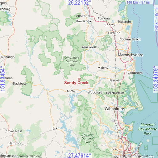
Sandy Creek GPS coordinates[2]
26° 51' 2.052" South, 152° 38' 15.576" East
| Map corner | latitude | longitude |
|---|---|---|
| Upper-left | -26.22152°, | 151.93454° |
| Center: | -26.85057°, | 152.63766° |
| Lower-right: | -27.47614°, | 153.34079° |
| Map W x H: | 139.5×139.5 km | = 86.7×86.7mi |
| max Lat: | -10.58257° ⇑14.2% North |
| Sandy Creek: | -26.85057° |
| min Lat: | ⇓85.8% South -43.31423° |
| min Long | Sandy Creek | max Long |
| 113.53327° | 152.63766° | 153.61246° |
| W 85.3%⇐ | ⇒14.7% E |
Elevation
Elevation of Sandy Creek is 163 m = 535 ft, and this is 41 m = 135 ft above average elevation for this country.
| Max E: |
1715 m = 5627 ft | 21.5% |
| Sandy Creek | 163 m 535 ft | |
| Avg. | 122 m = 400 ft | |
Min E: |
-2 m = -7 ft | 78.5% |
See also: Australia elevation on elevation.city.
Geographical zone
Sandy Creek is located in South temperate zone (between Tropic of Capricorn and the Antarctic Circle). Distance of this Southern Tropic circle is 379.6 km =235.9 mi to North.| Distance of | km | miles | from Sandy Creek |
|---|---|---|---|
| Equator | 2985.5 | 1855.1 | to North |
| Tropic Capricorn | 379.6 | 235.9 | to North |
| Antarctic Circle | 4415.7 | 2743.8 | to South |
| South Pole | 7021.6 | 4363 | to South |


Nearby cities:
15 places around Sandy Creek: (largest is in red/bold)
• Conondale
15.1 km =9.4 mi,  32°
32°
• Delaneys Creek
22.8 km =14.2 mi,  136°
136°
• D’Aguilar
21.8 km =13.5 mi,  132°
132°
• Flaxton
31.1 km =19.3 mi,  46°
46°
• Glass House Mountains
31.7 km =19.7 mi,  99°
99°
• Kenilworth
29.6 km =18.4 mi,  17°
17°
• Kilcoy
12.5 km =7.8 mi,  214°
214°
• Maleny
23.3 km =14.5 mi,  64°
64°
• Montville
30.7 km =19.1 mi, 52°
• North Maleny
24.5 km =15.2 mi, 63°
• Peachester
24.4 km =15.2 mi,  88°
88°
• Reesville
18 km =11.2 mi, 55°
• Wamuran
30.8 km =19.1 mi, 132°
• Witta
24.4 km =15.2 mi, 46°
• Woodford
17.9 km =11.1 mi, 129°
Sources, notices
• [Note1] Compared only with cities in Australia existing in our database
• [Src1] Map data: © OpenStreetMap contributors (CC-BY-SA)
• [Src2] Other city data from geonames.org with taken over terms of usage.
• [Src3] Geographical zone / Annual Mean Temperature by Robert A. Rohde @ Wikipedia
