Dayboro geodata
Dayboro (Queensland) is a populated place; located in Australia in Australia/Brisbane (GMT+10) time zone. With population of 2,134 people, there are 2802 cities with bigger population in this country. Compared to other cities in Australia, 85.2% of cities are located further ↓South; 87.3% of cities are located further ←West and 58% of cities have lower elevation than Dayboro. Note1


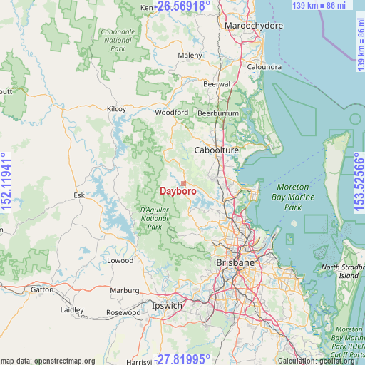
Dayboro GPS coordinates[2]
27° 11' 46.752" South, 152° 49' 21.108" East
| Map corner | latitude | longitude |
|---|---|---|
| Upper-left | -26.56918°, | 152.11941° |
| Center: | -27.19632°, | 152.82253° |
| Lower-right: | -27.81995°, | 153.52566° |
| Map W x H: | 139.1×139.1 km | = 86.4×86.4mi |
| max Lat: | -10.58257° ⇑14.8% North |
| Dayboro: | -27.19632° |
| min Lat: | ⇓85.2% South -43.31423° |
| min Long | Dayboro | max Long |
| 113.53327° | 152.82253° | 153.61246° |
| W 87.3%⇐ | ⇒12.7% E |
Elevation
Elevation of Dayboro is 59 m = 194 ft, and this is 63 m = 207 ft below average elevation for this country.
| Max E: |
1715 m = 5627 ft | 42% |
| Avg. | 122 m = 400 ft | |
| Dayboro | 59 m = 194 ft | |
Min E: |
-2 m = -7 ft | 58% |
See also: Australia elevation on elevation.city.
Geographical zone
Dayboro is located in South temperate zone (between Tropic of Capricorn and the Antarctic Circle). Distance of this Southern Tropic circle is 418 km =259.7 mi to North.| Distance of | km | miles | from Dayboro |
|---|---|---|---|
| Equator | 3023.9 | 1879 | to North |
| Tropic Capricorn | 418 | 259.7 | to North |
| Antarctic Circle | 4377.2 | 2719.9 | to South |
| South Pole | 6983.1 | 4339.1 | to South |


Nearby cities:
15 places around Dayboro: (largest is in red/bold)
• Bellmere
14.1 km =8.8 mi,  28°
28°
• Burpengary
14 km =8.7 mi,  72°
72°
• Cashmere
14 km =8.7 mi,  143°
143°
• Cedar Creek
15.3 km =9.5 mi,  181°
181°
• Clear Mountain
13.5 km =8.4 mi,  153°
153°
• Closeburn
15.1 km =9.4 mi,  164°
164°
• Joyner
15 km =9.3 mi,  126°
126°
• Kurwongbah
15.7 km =9.8 mi,  104°
104°
• Morayfield
15.9 km =9.9 mi,  52°
52°
• Mount Samson
11.8 km =7.3 mi,  166°
166°
• Narangba
13.5 km =8.4 mi,  93°
93°
• Ocean View
7.9 km =4.9 mi,  347°
347°
• Samson Vale
8.3 km =5.2 mi, 160°
• Upper Caboolture
10.7 km =6.6 mi, 34°
• Whiteside
11.1 km =6.9 mi, 127°
Sources, notices
• [Note1] Compared only with cities in Australia existing in our database
• [Src1] Map data: © OpenStreetMap contributors (CC-BY-SA)
• [Src2] Other city data from geonames.org with taken over terms of usage.
• [Src3] Geographical zone / Annual Mean Temperature by Robert A. Rohde @ Wikipedia
