Nathalia geodata
Nathalia (Victoria) is a populated place; located in Australia in Australia/Melbourne (GMT+11) time zone. With population of 1,830 people, there are 3021 cities with bigger population in this country. Compared to other cities in Australia, 78.6% of cities are located further ↑North; 62.6% of cities are located further →East and 70.4% of cities have lower elevation than Nathalia. Note1


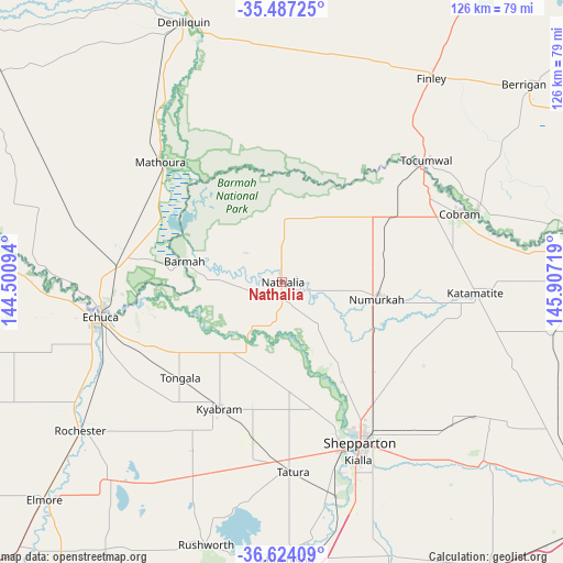
Nathalia GPS coordinates[2]
36° 3' 27.792" South, 145° 12' 14.616" East
| Map corner | latitude | longitude |
|---|---|---|
| Upper-left | -35.48725°, | 144.50094° |
| Center: | -36.05772°, | 145.20406° |
| Lower-right: | -36.62409°, | 145.90719° |
| Map W x H: | 126.4×126.4 km | = 78.5×78.5mi |
| max Lat: | -10.58257° ⇑78.6% North |
| Nathalia: | -36.05772° |
| min Lat: | ⇓21.4% South -43.31423° |
| min Long | Nathalia | max Long |
| 113.53327° | 145.20406° | 153.61246° |
| W 37.4%⇐ | ⇒62.6% E |
Elevation
Elevation of Nathalia is 105 m = 344 ft, and this is 17 m = 56 ft below average elevation for this country.
| Max E: |
1715 m = 5627 ft | 29.6% |
| Avg. | 122 m = 400 ft | |
| Nathalia | 105 m = 344 ft | |
Min E: |
-2 m = -7 ft | 70.4% |
See also: Australia elevation on elevation.city.
Geographical zone
Nathalia is located in South temperate zone (between Tropic of Capricorn and the Antarctic Circle). Distance of this Southern Tropic circle is 1403.3 km =872 mi to North.| Distance of | km | miles | from Nathalia |
|---|---|---|---|
| Equator | 4009.2 | 2491.2 | to North |
| Tropic Capricorn | 1403.3 | 872 | to North |
| Antarctic Circle | 3391.9 | 2107.6 | to South |
| South Pole | 5997.8 | 3726.9 | to South |


Nearby cities:
15 places around Nathalia: (largest is in red/bold)
• Congupna
33.9 km =21.1 mi,  142°
142°
• Echuca Village
35.8 km =22.2 mi,  256°
256°
• Grahamvale
38.4 km =23.9 mi,  147°
147°
• Invergordon
36.2 km =22.5 mi,  109°
109°
• Katunga
24.4 km =15.2 mi,  78°
78°
• Kyabram
31.6 km =19.6 mi,  205°
205°
• Mathoura
38.3 km =23.8 mi,  314°
314°
• Merrigum
35.6 km =22.1 mi,  190°
190°
• Mooroopna
40.2 km =25 mi,  161°
161°
• Numurkah
21.7 km =13.5 mi,  99°
99°
• Shepparton
39.9 km =24.8 mi, 154°
• Strathmerton
28.8 km =17.9 mi,  59°
59°
• Tallygaroopna
29.7 km =18.5 mi, 136°
• Tongala
31.2 km =19.4 mi,  225°
225°
• Yarroweyah
35.1 km =21.8 mi, 64°
Sources, notices
• [Note1] Compared only with cities in Australia existing in our database
• [Src1] Map data: © OpenStreetMap contributors (CC-BY-SA)
• [Src2] Other city data from geonames.org with taken over terms of usage.
• [Src3] Geographical zone / Annual Mean Temperature by Robert A. Rohde @ Wikipedia
