Strathmerton geodata
Strathmerton (Victoria) is a populated place; located in Australia in Australia/Melbourne (GMT+11) time zone. With population of 1,044 people, there are 3762 cities with bigger population in this country. Compared to other cities in Australia, 78.2% of cities are located further ↑North; 59.8% of cities are located further →East and 71.5% of cities have lower elevation than Strathmerton. Note1


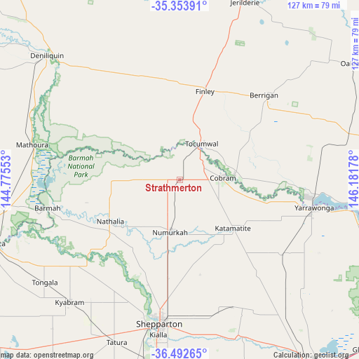
Strathmerton GPS coordinates[2]
35° 55' 31.188" South, 145° 28' 43.14" East
| Map corner | latitude | longitude |
|---|---|---|
| Upper-left | -35.35391°, | 144.77553° |
| Center: | -35.92533°, | 145.47865° |
| Lower-right: | -36.49265°, | 146.18178° |
| Map W x H: | 126.6×126.6 km | = 78.7×78.7mi |
| max Lat: | -10.58257° ⇑78.2% North |
| Strathmerton: | -35.92533° |
| min Lat: | ⇓21.8% South -43.31423° |
| min Long | Strathmerton | max Long |
| 113.53327° | 145.47865° | 153.61246° |
| W 40.2%⇐ | ⇒59.8% E |
Elevation
Elevation of Strathmerton is 110 m = 361 ft, and this is 12 m = 39 ft below average elevation for this country.
| Max E: |
1715 m = 5627 ft | 28.5% |
| Avg. | 122 m = 400 ft | |
| Strathmerton | 110 m = 361 ft | |
Min E: |
-2 m = -7 ft | 71.5% |
See also: Australia elevation on elevation.city.
Geographical zone
Strathmerton is located in South temperate zone (between Tropic of Capricorn and the Antarctic Circle). Distance of this Southern Tropic circle is 1388.6 km =862.8 mi to North.| Distance of | km | miles | from Strathmerton |
|---|---|---|---|
| Equator | 3994.5 | 2482.1 | to North |
| Tropic Capricorn | 1388.6 | 862.8 | to North |
| Antarctic Circle | 3406.7 | 2116.8 | to South |
| South Pole | 6012.5 | 3736 | to South |


Nearby cities:
15 places around Strathmerton: (largest is in red/bold)
• Barooga
19.7 km =12.2 mi,  83°
83°
• Berrigan
42.2 km =26.2 mi,  45°
45°
• Cobram
14.6 km =9.1 mi,  87°
87°
• Congupna
41.9 km =26 mi,  185°
185°
• Finley
31.2 km =19.4 mi,  15°
15°
• Grahamvale
47.2 km =29.3 mi,  184°
184°
• Invergordon
28.4 km =17.6 mi,  160°
160°
• Katunga
9.8 km =6.1 mi, 184°
• Mulwala
47.9 km =29.8 mi,  98°
98°
• Nathalia
28.8 km =17.9 mi,  239°
239°
• Numurkah
18.4 km =11.4 mi, 190°
• Tallygaroopna
36.3 km =22.6 mi, 186°
• Tocumwal
15.1 km =9.4 mi,  32°
32°
• Yarrawonga
48 km =29.8 mi, 102°
• Yarroweyah
7.1 km =4.4 mi, 88°
Sources, notices
• [Note1] Compared only with cities in Australia existing in our database
• [Src1] Map data: © OpenStreetMap contributors (CC-BY-SA)
• [Src2] Other city data from geonames.org with taken over terms of usage.
• [Src3] Geographical zone / Annual Mean Temperature by Robert A. Rohde @ Wikipedia
