Sunbury geodata
Sunbury (Victoria) is a section of populated place; located in Australia in Australia/Melbourne (GMT+11) time zone. With population of 35,449 people, there are 47 cities with bigger population in this country. Compared to other cities in Australia, 83.2% of cities are located further ↑North; 69.5% of cities are located further →East and 83.2% of cities have lower elevation than Sunbury. Note1


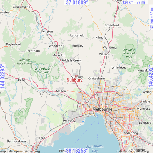
Sunbury GPS coordinates[2]
37° 34' 38.712" South, 144° 43' 33.852" East
| Map corner | latitude | longitude |
|---|---|---|
| Upper-left | -37.01809°, | 144.02295° |
| Center: | -37.57742°, | 144.72607° |
| Lower-right: | -38.13258°, | 145.4292° |
| Map W x H: | 123.9×123.9 km | = 77×77mi |
| max Lat: | -10.58257° ⇑83.2% North |
| Sunbury: | -37.57742° |
| min Lat: | ⇓16.8% South -43.31423° |
| min Long | Sunbury | max Long |
| 113.53327° | 144.72607° | 153.61246° |
| W 30.5%⇐ | ⇒69.5% E |
Elevation
Elevation of Sunbury is 220 m = 722 ft, and this is 98 m = 322 ft above average elevation for this country.
| Max E: |
1715 m = 5627 ft | 16.8% |
| Sunbury | 220 m 722 ft | |
| Avg. | 122 m = 400 ft | |
Min E: |
-2 m = -7 ft | 83.2% |
See also: Australia elevation on elevation.city.
Geographical zone
Sunbury is located in South temperate zone (between Tropic of Capricorn and the Antarctic Circle). Distance of this Southern Tropic circle is 1572.3 km =977 mi to North.| Distance of | km | miles | from Sunbury |
|---|---|---|---|
| Equator | 4178.2 | 2596.2 | to North |
| Tropic Capricorn | 1572.3 | 977 | to North |
| Antarctic Circle | 3223 | 2002.7 | to South |
| South Pole | 5828.8 | 3621.8 | to South |


Nearby cities:
15 places around Sunbury: (largest is in red/bold)
• Bulla
9.9 km =6.2 mi,  133°
133°
• Diggers Rest
5.4 km =3.4 mi,  186°
186°
• Gisborne
15.3 km =9.5 mi,  310°
310°
• Gisborne South
11.4 km =7.1 mi,  290°
290°
• Greenvale
13.9 km =8.6 mi,  116°
116°
• Hillside
12.6 km =7.8 mi,  173°
173°
• Keilor Lodge
15.2 km =9.4 mi,  153°
153°
• Kurunjang
15.8 km =9.8 mi,  226°
226°
• Melbourne Airport
15.4 km =9.6 mi, 134°
• Mickleham
16.2 km =10.1 mi,  73°
73°
• Plumpton
12.6 km =7.8 mi, 194°
• Sydenham
14.1 km =8.8 mi, 165°
• Taylors Hill
14.9 km =9.3 mi, 170°
• Taylors Lakes
14.5 km =9 mi,  158°
158°
• Toolern Vale
11.4 km =7.1 mi,  257°
257°
Sources, notices
• [Note1] Compared only with cities in Australia existing in our database
• [Src1] Map data: © OpenStreetMap contributors (CC-BY-SA)
• [Src2] Other city data from geonames.org with taken over terms of usage.
• [Src3] Geographical zone / Annual Mean Temperature by Robert A. Rohde @ Wikipedia
