Gisborne geodata
Gisborne (Victoria) is a populated place; located in Australia in Australia/Melbourne (GMT+11) time zone. With population of 8,725 people, there are 730 cities with bigger population in this country. Compared to other cities in Australia, 82.5% of cities are located further ↑North; 69.9% of cities are located further →East and 91.3% of cities have lower elevation than Gisborne. Note1


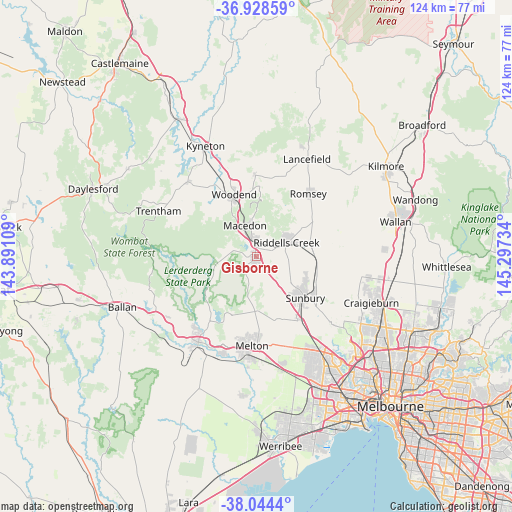
Gisborne GPS coordinates[2]
37° 29' 18.888" South, 144° 35' 39.156" East
| Map corner | latitude | longitude |
|---|---|---|
| Upper-left | -36.92859°, | 143.89109° |
| Center: | -37.48858°, | 144.59421° |
| Lower-right: | -38.0444°, | 145.29734° |
| Map W x H: | 124.1×124.1 km | = 77.1×77.1mi |
| max Lat: | -10.58257° ⇑82.5% North |
| Gisborne: | -37.48858° |
| min Lat: | ⇓17.5% South -43.31423° |
| min Long | Gisborne | max Long |
| 113.53327° | 144.59421° | 153.61246° |
| W 30.1%⇐ | ⇒69.9% E |
Elevation
Elevation of Gisborne is 421 m = 1381 ft, and this is 299 m = 981 ft above average elevation for this country.
| Max E: |
1715 m = 5627 ft | 8.7% |
| Gisborne | 421 m 1381 ft | |
| Avg. | 122 m = 400 ft | |
Min E: |
-2 m = -7 ft | 91.3% |
See also: Australia elevation on elevation.city.
Geographical zone
Gisborne is located in South temperate zone (between Tropic of Capricorn and the Antarctic Circle). Distance of this Southern Tropic circle is 1562.4 km =970.8 mi to North.| Distance of | km | miles | from Gisborne |
|---|---|---|---|
| Equator | 4168.3 | 2590.1 | to North |
| Tropic Capricorn | 1562.4 | 970.8 | to North |
| Antarctic Circle | 3232.8 | 2008.8 | to South |
| South Pole | 5838.7 | 3628 | to South |


Nearby cities:
15 places around Gisborne: (largest is in red/bold)
• Bullengarook
10.3 km =6.4 mi,  252°
252°
• Darley
23.1 km =14.4 mi,  215°
215°
• Diggers Rest
18.8 km =11.7 mi,  144°
144°
• Gisborne South
5.9 km =3.7 mi,  170°
170°
• Kurunjang
20.8 km =12.9 mi,  179°
179°
• Macedon
8.2 km =5.1 mi,  339°
339°
• Melton
21.7 km =13.5 mi, 182°
• Melton West
21.2 km =13.2 mi,  186°
186°
• Mount Macedon
9.8 km =6.1 mi,  354°
354°
• New Gisborne
3.1 km =1.9 mi,  8°
8°
• Plumpton
23.6 km =14.7 mi,  158°
158°
• Romsey
20.2 km =12.6 mi,  40°
40°
• Sunbury
15.3 km =9.5 mi,  130°
130°
• Toolern Vale
12.4 km =7.7 mi, 177°
• Woodend
16 km =9.9 mi, 338°
Sources, notices
• [Note1] Compared only with cities in Australia existing in our database
• [Src1] Map data: © OpenStreetMap contributors (CC-BY-SA)
• [Src2] Other city data from geonames.org with taken over terms of usage.
• [Src3] Geographical zone / Annual Mean Temperature by Robert A. Rohde @ Wikipedia
