Mickleham geodata
Mickleham (Victoria) is a section of populated place; located in Australia in Australia/Melbourne (GMT+11) time zone. With population of 3,132 people, there are 2163 cities with bigger population in this country. Compared to other cities in Australia, 82.8% of cities are located further ↑North; 67.8% of cities are located further →East and 85.5% of cities have lower elevation than Mickleham. Note1


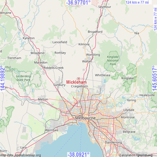
Mickleham GPS coordinates[2]
37° 32' 11.904" South, 144° 54' 7.344" East
| Map corner | latitude | longitude |
|---|---|---|
| Upper-left | -36.97701°, | 144.19892° |
| Center: | -37.53664°, | 144.90204° |
| Lower-right: | -38.0921°, | 145.60517° |
| Map W x H: | 124×124 km | = 77.1×77.1mi |
| max Lat: | -10.58257° ⇑82.8% North |
| Mickleham: | -37.53664° |
| min Lat: | ⇓17.2% South -43.31423° |
| min Long | Mickleham | max Long |
| 113.53327° | 144.90204° | 153.61246° |
| W 32.2%⇐ | ⇒67.8% E |
Elevation
Elevation of Mickleham is 256 m = 840 ft, and this is 134 m = 440 ft above average elevation for this country.
| Max E: |
1715 m = 5627 ft | 14.5% |
| Mickleham | 256 m 840 ft | |
| Avg. | 122 m = 400 ft | |
Min E: |
-2 m = -7 ft | 85.5% |
See also: Australia elevation on elevation.city.
Geographical zone
Mickleham is located in South temperate zone (between Tropic of Capricorn and the Antarctic Circle). Distance of this Southern Tropic circle is 1567.8 km =974.2 mi to North.| Distance of | km | miles | from Mickleham |
|---|---|---|---|
| Equator | 4173.7 | 2593.4 | to North |
| Tropic Capricorn | 1567.8 | 974.2 | to North |
| Antarctic Circle | 3227.5 | 2005.5 | to South |
| South Pole | 5833.4 | 3624.7 | to South |


Nearby cities:
15 places around Mickleham: (largest is in red/bold)
• Attwood
14.8 km =9.2 mi,  185°
185°
• Beveridge
9.3 km =5.8 mi,  50°
50°
• Broadmeadows
16 km =9.9 mi,  174°
174°
• Bulla
14.1 km =8.8 mi,  216°
216°
• Campbellfield
15 km =9.3 mi,  160°
160°
• Coolaroo
13.7 km =8.5 mi, 167°
• Craigieburn
8.2 km =5.1 mi,  149°
149°
• Dallas
15.2 km =9.4 mi, 168°
• Greenvale
11.2 km =7 mi,  196°
196°
• Meadow Heights
12.8 km =8 mi, 173°
• Melbourne Airport
15.9 km =9.9 mi, 196°
• Roxburgh Park
10.1 km =6.3 mi, 168°
• Wallan
15 km =9.3 mi,  26°
26°
• Westmeadows
15.6 km =9.7 mi,  184°
184°
• Wollert
12.7 km =7.9 mi,  114°
114°
Sources, notices
• [Note1] Compared only with cities in Australia existing in our database
• [Src1] Map data: © OpenStreetMap contributors (CC-BY-SA)
• [Src2] Other city data from geonames.org with taken over terms of usage.
• [Src3] Geographical zone / Annual Mean Temperature by Robert A. Rohde @ Wikipedia
