Rosebud geodata
Rosebud (Victoria) is a section of populated place; located in Australia in Australia/Melbourne (GMT+11) time zone. With population of 12,871 people, there are 362 cities with bigger population in this country. Compared to other cities in Australia, 95.2% of cities are located further ↑North; 67.8% of cities are located further →East and 90.1% of cities have higher elevation than Rosebud. Note1


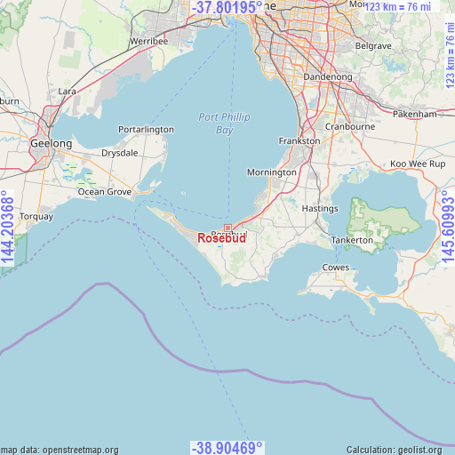
Rosebud GPS coordinates[2]
38° 21' 19.512" South, 144° 54' 24.48" East
| Map corner | latitude | longitude |
|---|---|---|
| Upper-left | -37.80195°, | 144.20368° |
| Center: | -38.35542°, | 144.9068° |
| Lower-right: | -38.90469°, | 145.60993° |
| Map W x H: | 122.6×122.6 km | = 76.2×76.2mi |
| max Lat: | -10.58257° ⇑95.2% North |
| Rosebud: | -38.35542° |
| min Lat: | ⇓4.8% South -43.31423° |
| min Long | Rosebud | max Long |
| 113.53327° | 144.9068° | 153.61246° |
| W 32.2%⇐ | ⇒67.8% E |
Elevation
Elevation of Rosebud is 9 m = 30 ft, and this is 113 m = 371 ft below average elevation for this country.
| Max E: |
1715 m = 5627 ft | 90.1% |
| Avg. | 122 m = 400 ft | |
| Rosebud | 9 m = 30 ft | |
Min E: |
-2 m = -7 ft | 9.9% |
See also: Australia elevation on elevation.city.
Geographical zone
Rosebud is located in South temperate zone (between Tropic of Capricorn and the Antarctic Circle). Distance of this Southern Tropic circle is 1658.8 km =1030.7 mi to North.| Distance of | km | miles | from Rosebud |
|---|---|---|---|
| Equator | 4264.7 | 2650 | to North |
| Tropic Capricorn | 1658.8 | 1030.7 | to North |
| Antarctic Circle | 3136.5 | 1948.9 | to South |
| South Pole | 5742.3 | 3568.1 | to South |


Nearby cities:
15 places around Rosebud: (largest is in red/bold)
• Blairgowrie
11.1 km =6.9 mi,  266°
266°
• Dromana
5.6 km =3.5 mi,  64°
64°
• Fingal
8.2 km =5.1 mi,  217°
217°
• Flinders
16.6 km =10.3 mi,  142°
142°
• McCrae
2 km =1.2 mi,  71°
71°
• Mount Martha
13.8 km =8.6 mi,  44°
44°
• Red Hill
9.6 km =6 mi,  86°
86°
• Red Hill South
11.5 km =7.1 mi,  105°
105°
• Rosebud West
2.7 km =1.7 mi,  248°
248°
• Rye
8.9 km =5.5 mi, 248°
• Safety Beach
9.3 km =5.8 mi, 61°
• Saint Andrews Beach
9.7 km =6 mi,  227°
227°
• Shoreham
14.5 km =9 mi,  122°
122°
• Sorrento
14.5 km =9 mi,  276°
276°
• Tootgarook
5.5 km =3.4 mi,  243°
243°
Sources, notices
• [Note1] Compared only with cities in Australia existing in our database
• [Src1] Map data: © OpenStreetMap contributors (CC-BY-SA)
• [Src2] Other city data from geonames.org with taken over terms of usage.
• [Src3] Geographical zone / Annual Mean Temperature by Robert A. Rohde @ Wikipedia
