Shoreham geodata
Shoreham (Victoria) is a section of populated place; located in Australia in Australia/Melbourne (GMT+11) time zone. With population of 573 people, there are 4640 cities with bigger population in this country. Compared to other cities in Australia, 95.7% of cities are located further ↑North; 65.4% of cities are located further →East and 58.5% of cities have lower elevation than Shoreham. Note1


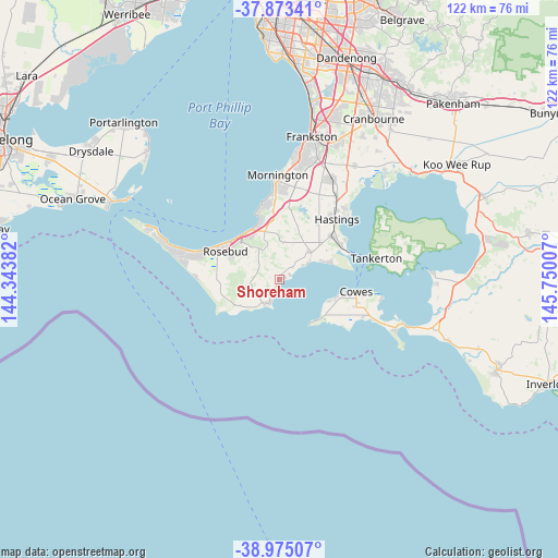
Shoreham GPS coordinates[2]
38° 25' 34.824" South, 145° 2' 48.984" East
| Map corner | latitude | longitude |
|---|---|---|
| Upper-left | -37.87341°, | 144.34382° |
| Center: | -38.42634°, | 145.04694° |
| Lower-right: | -38.97507°, | 145.75007° |
| Map W x H: | 122.5×122.5 km | = 76.1×76.1mi |
| max Lat: | -10.58257° ⇑95.7% North |
| Shoreham: | -38.42634° |
| min Lat: | ⇓4.3% South -43.31423° |
| min Long | Shoreham | max Long |
| 113.53327° | 145.04694° | 153.61246° |
| W 34.6%⇐ | ⇒65.4% E |
Elevation
Elevation of Shoreham is 60 m = 197 ft, and this is 62 m = 203 ft below average elevation for this country.
| Max E: |
1715 m = 5627 ft | 41.5% |
| Avg. | 122 m = 400 ft | |
| Shoreham | 60 m = 197 ft | |
Min E: |
-2 m = -7 ft | 58.5% |
See also: Australia elevation on elevation.city.
Geographical zone
Shoreham is located in South temperate zone (between Tropic of Capricorn and the Antarctic Circle). Distance of this Southern Tropic circle is 1666.7 km =1035.6 mi to North.| Distance of | km | miles | from Shoreham |
|---|---|---|---|
| Equator | 4272.6 | 2654.9 | to North |
| Tropic Capricorn | 1666.7 | 1035.6 | to North |
| Antarctic Circle | 3128.6 | 1944 | to South |
| South Pole | 5734.5 | 3563.3 | to South |


Nearby cities:
15 places around Shoreham: (largest is in red/bold)
• Balnarring
10 km =6.2 mi,  48°
48°
• Bittern
14.7 km =9.1 mi, 45°
• Cowes
16.9 km =10.5 mi,  99°
99°
• Crib Point
15.8 km =9.8 mi,  57°
57°
• Dromana
12.6 km =7.8 mi,  325°
325°
• Flinders
5.7 km =3.5 mi,  202°
202°
• Hmas Cerberus
15 km =9.3 mi, 62°
• McCrae
13.4 km =8.3 mi,  309°
309°
• Red Hill
8.9 km =5.5 mi,  342°
342°
• Red Hill South
4.9 km =3 mi,  346°
346°
• Rosebud
14.5 km =9 mi,  302°
302°
• Rosebud West
16.3 km =10.1 mi,  294°
294°
• Safety Beach
13 km =8.1 mi, 341°
• Somers
11 km =6.8 mi, 62°
• Ventnor
13.5 km =8.4 mi,  107°
107°
Sources, notices
• [Note1] Compared only with cities in Australia existing in our database
• [Src1] Map data: © OpenStreetMap contributors (CC-BY-SA)
• [Src2] Other city data from geonames.org with taken over terms of usage.
• [Src3] Geographical zone / Annual Mean Temperature by Robert A. Rohde @ Wikipedia
