Tootgarook geodata
Tootgarook (Victoria) is a section of populated place; located in Australia in Australia/Melbourne (GMT+11) time zone. With population of 2,813 people, there are 2372 cities with bigger population in this country. Compared to other cities in Australia, 95.4% of cities are located further ↑North; 68.5% of cities are located further →East and 91.8% of cities have higher elevation than Tootgarook. Note1


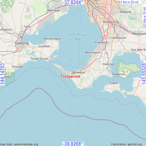
Tootgarook GPS coordinates[2]
38° 22' 39.72" South, 144° 51' 0.54" East
| Map corner | latitude | longitude |
|---|---|---|
| Upper-left | -37.8244°, | 144.14703° |
| Center: | -38.3777°, | 144.85015° |
| Lower-right: | -38.9268°, | 145.55328° |
| Map W x H: | 122.6×122.6 km | = 76.2×76.2mi |
| max Lat: | -10.58257° ⇑95.4% North |
| Tootgarook: | -38.3777° |
| min Lat: | ⇓4.6% South -43.31423° |
| min Long | Tootgarook | max Long |
| 113.53327° | 144.85015° | 153.61246° |
| W 31.5%⇐ | ⇒68.5% E |
Elevation
Elevation of Tootgarook is 8 m = 26 ft, and this is 114 m = 374 ft below average elevation for this country.
| Max E: |
1715 m = 5627 ft | 91.8% |
| Avg. | 122 m = 400 ft | |
| Tootgarook | 8 m = 26 ft | |
Min E: |
-2 m = -7 ft | 8.2% |
See also: Australia elevation on elevation.city.
Geographical zone
Tootgarook is located in South temperate zone (between Tropic of Capricorn and the Antarctic Circle). Distance of this Southern Tropic circle is 1661.3 km =1032.3 mi to North.| Distance of | km | miles | from Tootgarook |
|---|---|---|---|
| Equator | 4267.2 | 2651.5 | to North |
| Tropic Capricorn | 1661.3 | 1032.3 | to North |
| Antarctic Circle | 3134 | 1947.4 | to South |
| South Pole | 5739.9 | 3566.6 | to South |


Nearby cities:
15 places around Tootgarook: (largest is in red/bold)
• Blairgowrie
6.4 km =4 mi,  286°
286°
• Dromana
11.1 km =6.9 mi,  63°
63°
• Fingal
4 km =2.5 mi,  180°
180°
• Flinders
18.4 km =11.4 mi,  125°
125°
• McCrae
7.5 km =4.7 mi,  65°
65°
• Mount Martha
19.1 km =11.9 mi,  49°
49°
• Red Hill
14.8 km =9.2 mi,  78°
78°
• Red Hill South
16 km =9.9 mi,  92°
92°
• Rosebud
5.5 km =3.4 mi, 63°
• Rosebud West
2.8 km =1.7 mi, 58°
• Rye
3.4 km =2.1 mi,  255°
255°
• Safety Beach
14.8 km =9.2 mi, 62°
• Saint Andrews Beach
4.6 km =2.9 mi,  209°
209°
• Shoreham
18 km =11.2 mi,  107°
107°
• Sorrento
10.4 km =6.5 mi, 294°
Sources, notices
• [Note1] Compared only with cities in Australia existing in our database
• [Src1] Map data: © OpenStreetMap contributors (CC-BY-SA)
• [Src2] Other city data from geonames.org with taken over terms of usage.
• [Src3] Geographical zone / Annual Mean Temperature by Robert A. Rohde @ Wikipedia
