Fingal geodata
Fingal (Victoria) is a section of populated place; located in Australia in Australia/Melbourne (GMT+11) time zone. With population of 516 people, there are 4827 cities with bigger population in this country. Compared to other cities in Australia, 95.6% of cities are located further ↑North; 68.5% of cities are located further →East and 91.8% of cities have higher elevation than Fingal. Note1


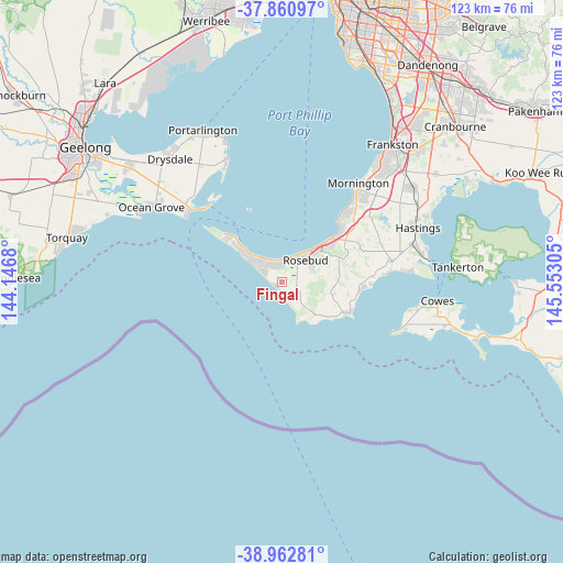
Fingal GPS coordinates[2]
38° 24' 50.364" South, 144° 50' 59.712" East
| Map corner | latitude | longitude |
|---|---|---|
| Upper-left | -37.86097°, | 144.1468° |
| Center: | -38.41399°, | 144.84992° |
| Lower-right: | -38.96281°, | 145.55305° |
| Map W x H: | 122.5×122.5 km | = 76.1×76.1mi |
| max Lat: | -10.58257° ⇑95.6% North |
| Fingal: | -38.41399° |
| min Lat: | ⇓4.4% South -43.31423° |
| min Long | Fingal | max Long |
| 113.53327° | 144.84992° | 153.61246° |
| W 31.5%⇐ | ⇒68.5% E |
Elevation
Elevation of Fingal is 8 m = 26 ft, and this is 114 m = 374 ft below average elevation for this country.
| Max E: |
1715 m = 5627 ft | 91.8% |
| Avg. | 122 m = 400 ft | |
| Fingal | 8 m = 26 ft | |
Min E: |
-2 m = -7 ft | 8.2% |
See also: Australia elevation on elevation.city.
Geographical zone
Fingal is located in South temperate zone (between Tropic of Capricorn and the Antarctic Circle). Distance of this Southern Tropic circle is 1665.3 km =1034.8 mi to North.| Distance of | km | miles | from Fingal |
|---|---|---|---|
| Equator | 4271.2 | 2654 | to North |
| Tropic Capricorn | 1665.3 | 1034.8 | to North |
| Antarctic Circle | 3129.9 | 1944.8 | to South |
| South Pole | 5735.8 | 3564.1 | to South |


Nearby cities:
15 places around Fingal: (largest is in red/bold)
• Blairgowrie
8.5 km =5.3 mi,  313°
313°
• Dromana
13.4 km =8.3 mi,  48°
48°
• Flinders
16.4 km =10.2 mi,  113°
113°
• McCrae
9.9 km =6.2 mi,  43°
43°
• Mount Martha
21.9 km =13.6 mi, 41°
• Red Hill
16.2 km =10.1 mi,  63°
63°
• Red Hill South
16.3 km =10.1 mi,  77°
77°
• Rosebud
8.2 km =5.1 mi, 37°
• Rosebud West
6 km =3.7 mi,  23°
23°
• Rye
4.6 km =2.9 mi, 314°
• Safety Beach
17.1 km =10.6 mi, 50°
• Saint Andrews Beach
2.2 km =1.4 mi,  269°
269°
• Shoreham
17.2 km =10.7 mi,  94°
94°
• Sorrento
12.6 km =7.8 mi, 311°
• Tootgarook
4 km =2.5 mi,  0°
0°
Sources, notices
• [Note1] Compared only with cities in Australia existing in our database
• [Src1] Map data: © OpenStreetMap contributors (CC-BY-SA)
• [Src2] Other city data from geonames.org with taken over terms of usage.
• [Src3] Geographical zone / Annual Mean Temperature by Robert A. Rohde @ Wikipedia
