Red Hill South geodata
Red Hill South (Victoria) is a section of populated place; located in Australia in Australia/Melbourne (GMT+11) time zone. With population of 584 people, there are 4611 cities with bigger population in this country. Compared to other cities in Australia, 95.5% of cities are located further ↑North; 65.8% of cities are located further →East and 78.1% of cities have lower elevation than Red Hill South. Note1


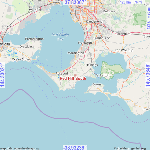
Red Hill South GPS coordinates[2]
38° 22' 59.988" South, 145° 1' 59.988" East
| Map corner | latitude | longitude |
|---|---|---|
| Upper-left | -37.83007°, | 144.33021° |
| Center: | -38.38333°, | 145.03333° |
| Lower-right: | -38.93239°, | 145.73646° |
| Map W x H: | 122.6×122.6 km | = 76.2×76.2mi |
| max Lat: | -10.58257° ⇑95.5% North |
| Red Hill South: | -38.38333° |
| min Lat: | ⇓4.5% South -43.31423° |
| min Long | Red Hill South | max Long |
| 113.53327° | 145.03333° | 153.61246° |
| W 34.2%⇐ | ⇒65.8% E |
Elevation
Elevation of Red Hill South is 157 m = 515 ft, and this is 35 m = 115 ft above average elevation for this country.
| Max E: |
1715 m = 5627 ft | 21.9% |
| Red Hill South | 157 m 515 ft | |
| Avg. | 122 m = 400 ft | |
Min E: |
-2 m = -7 ft | 78.1% |
See also: Australia elevation on elevation.city.
Geographical zone
Red Hill South is located in South temperate zone (between Tropic of Capricorn and the Antarctic Circle). Distance of this Southern Tropic circle is 1661.9 km =1032.7 mi to North.| Distance of | km | miles | from Red Hill South |
|---|---|---|---|
| Equator | 4267.8 | 2651.9 | to North |
| Tropic Capricorn | 1661.9 | 1032.7 | to North |
| Antarctic Circle | 3133.3 | 1946.9 | to South |
| South Pole | 5739.2 | 3566.2 | to South |


Nearby cities:
15 places around Red Hill South: (largest is in red/bold)
• Balnarring
8.9 km =5.5 mi,  78°
78°
• Bittern
12.9 km =8 mi,  64°
64°
• Crib Point
15 km =9.3 mi, 75°
• Dromana
8.1 km =5 mi,  312°
312°
• Flinders
10.1 km =6.3 mi,  185°
185°
• Hastings
16 km =9.9 mi,  54°
54°
• Hmas Cerberus
14.7 km =9.1 mi, 81°
• McCrae
9.9 km =6.2 mi,  292°
292°
• Mount Martha
13.1 km =8.1 mi,  353°
353°
• Red Hill
4 km =2.5 mi,  338°
338°
• Rosebud
11.5 km =7.1 mi, 285°
• Rosebud West
13.7 km =8.5 mi,  278°
278°
• Safety Beach
8.1 km =5 mi, 339°
• Shoreham
4.9 km =3 mi,  166°
166°
• Somers
11 km =6.8 mi,  88°
88°
Sources, notices
• [Note1] Compared only with cities in Australia existing in our database
• [Src1] Map data: © OpenStreetMap contributors (CC-BY-SA)
• [Src2] Other city data from geonames.org with taken over terms of usage.
• [Src3] Geographical zone / Annual Mean Temperature by Robert A. Rohde @ Wikipedia
