Red Cliffs geodata
Red Cliffs (Victoria) is a populated place; located in Australia in Australia/Melbourne (GMT+11) time zone. With population of 4,927 people, there are 1494 cities with bigger population in this country. Compared to other cities in Australia, 61.9% of cities are located further ↑North; 74.7% of cities are located further →East and 63.4% of cities have lower elevation than Red Cliffs. Note1


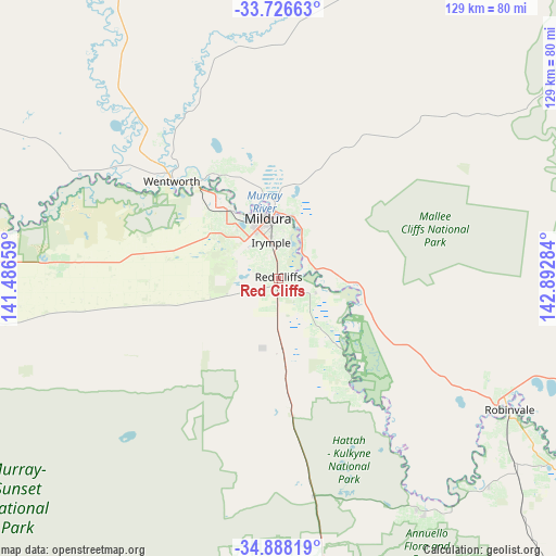
Red Cliffs GPS coordinates[2]
34° 18' 33.912" South, 142° 11' 22.956" East
| Map corner | latitude | longitude |
|---|---|---|
| Upper-left | -33.72663°, | 141.48659° |
| Center: | -34.30942°, | 142.18971° |
| Lower-right: | -34.88819°, | 142.89284° |
| Map W x H: | 129.2×129.2 km | = 80.3×80.3mi |
| max Lat: | -10.58257° ⇑61.9% North |
| Red Cliffs: | -34.30942° |
| min Lat: | ⇓38.1% South -43.31423° |
| min Long | Red Cliffs | max Long |
| 113.53327° | 142.18971° | 153.61246° |
| W 25.3%⇐ | ⇒74.7% E |
Elevation
Elevation of Red Cliffs is 74 m = 243 ft, and this is 48 m = 157 ft below average elevation for this country.
| Max E: |
1715 m = 5627 ft | 36.6% |
| Avg. | 122 m = 400 ft | |
| Red Cliffs | 74 m = 243 ft | |
Min E: |
-2 m = -7 ft | 63.4% |
See also: Australia elevation on elevation.city.
Geographical zone
Red Cliffs is located in South temperate zone (between Tropic of Capricorn and the Antarctic Circle). Distance of this Southern Tropic circle is 1208.9 km =751.2 mi to North.| Distance of | km | miles | from Red Cliffs |
|---|---|---|---|
| Equator | 3814.8 | 2370.4 | to North |
| Tropic Capricorn | 1208.9 | 751.2 | to North |
| Antarctic Circle | 3586.3 | 2228.4 | to South |
| South Pole | 6192.2 | 3847.7 | to South |


Nearby cities:
15 places around Red Cliffs: (largest is in red/bold)
• Birdwoodton
16.3 km =10.1 mi,  317°
317°
• Buronga
15.5 km =9.6 mi,  354°
354°
• Cardross
5.9 km =3.7 mi,  272°
272°
• Coomealla
25.1 km =15.6 mi,  339°
339°
• Dareton
27.6 km =17.1 mi,  329°
329°
• Euston
58.8 km =36.5 mi,  120°
120°
• Gol Gol
15.4 km =9.6 mi,  11°
11°
• Irymple
8.4 km =5.2 mi, 348°
• Merbein
19.4 km =12.1 mi, 324°
• Mildura
14 km =8.7 mi, 349°
• Nichols Point
11.1 km =6.9 mi, 11°
• Ouyen
85.5 km =53.1 mi,  171°
171°
• Paringa
129.9 km =80.7 mi,  276°
276°
• Robinvale
61.5 km =38.2 mi, 119°
• Wentworth
33.9 km =21.1 mi,  311°
311°
Sources, notices
• [Note1] Compared only with cities in Australia existing in our database
• [Src1] Map data: © OpenStreetMap contributors (CC-BY-SA)
• [Src2] Other city data from geonames.org with taken over terms of usage.
• [Src3] Geographical zone / Annual Mean Temperature by Robert A. Rohde @ Wikipedia
