Buronga geodata
Buronga (New South Wales) is a populated place; located in Australia in Australia/Sydney (GMT+11) time zone. With population of 1,350 people, there are 3417 cities with bigger population in this country. Compared to other cities in Australia, 61% of cities are located further ↑North; 74.7% of cities are located further →East and 52.4% of cities have higher elevation than Buronga. Note1


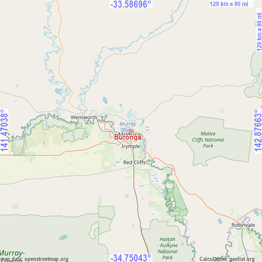
Buronga GPS coordinates[2]
34° 10' 14.52" South, 142° 10' 24.6" East
| Map corner | latitude | longitude |
|---|---|---|
| Upper-left | -33.58696°, | 141.47038° |
| Center: | -34.1707°, | 142.1735° |
| Lower-right: | -34.75043°, | 142.87663° |
| Map W x H: | 129.4×129.4 km | = 80.4×80.4mi |
| max Lat: | -10.58257° ⇑61% North |
| Buronga: | -34.1707° |
| min Lat: | ⇓39% South -43.31423° |
| min Long | Buronga | max Long |
| 113.53327° | 142.1735° | 153.61246° |
| W 25.3%⇐ | ⇒74.7% E |
Elevation
Elevation of Buronga is 42 m = 138 ft, and this is 80 m = 262 ft below average elevation for this country.
| Max E: |
1715 m = 5627 ft | 52.4% |
| Avg. | 122 m = 400 ft | |
| Buronga | 42 m = 138 ft | |
Min E: |
-2 m = -7 ft | 47.6% |
See also: Australia elevation on elevation.city.
Geographical zone
Buronga is located in South temperate zone (between Tropic of Capricorn and the Antarctic Circle). Distance of this Southern Tropic circle is 1193.5 km =741.6 mi to North.| Distance of | km | miles | from Buronga |
|---|---|---|---|
| Equator | 3799.4 | 2360.8 | to North |
| Tropic Capricorn | 1193.5 | 741.6 | to North |
| Antarctic Circle | 3601.7 | 2238 | to South |
| South Pole | 6207.6 | 3857.2 | to South |


Nearby cities:
15 places around Buronga: (largest is in red/bold)
• Birdwoodton
10.1 km =6.3 mi,  250°
250°
• Cardross
15.8 km =9.8 mi,  196°
196°
• Coomealla
11 km =6.8 mi,  317°
317°
• Dareton
14.9 km =9.3 mi,  304°
304°
• Euston
69 km =42.9 mi,  130°
130°
• Gol Gol
4.5 km =2.8 mi,  94°
94°
• Irymple
7.2 km =4.5 mi,  181°
181°
• Merbein
9.9 km =6.2 mi,  271°
271°
• Mildura
1.9 km =1.2 mi,  211°
211°
• Nichols Point
5.9 km =3.7 mi,  140°
140°
• Ouyen
101 km =62.8 mi,  172°
172°
• Paringa
127.7 km =79.3 mi, 269°
• Red Cliffs
15.5 km =9.6 mi, 174°
• Robinvale
71.6 km =44.5 mi, 129°
• Wentworth
25 km =15.5 mi,  286°
286°
Sources, notices
• [Note1] Compared only with cities in Australia existing in our database
• [Src1] Map data: © OpenStreetMap contributors (CC-BY-SA)
• [Src2] Other city data from geonames.org with taken over terms of usage.
• [Src3] Geographical zone / Annual Mean Temperature by Robert A. Rohde @ Wikipedia
