Ouyen geodata
Ouyen (Victoria) is a populated place; located in Australia in Australia/Melbourne (GMT+11) time zone. With population of 1,185 people, there are 3603 cities with bigger population in this country. Compared to other cities in Australia, 72.7% of cities are located further ↑North; 74.5% of cities are located further →East and 56.3% of cities have lower elevation than Ouyen. Note1


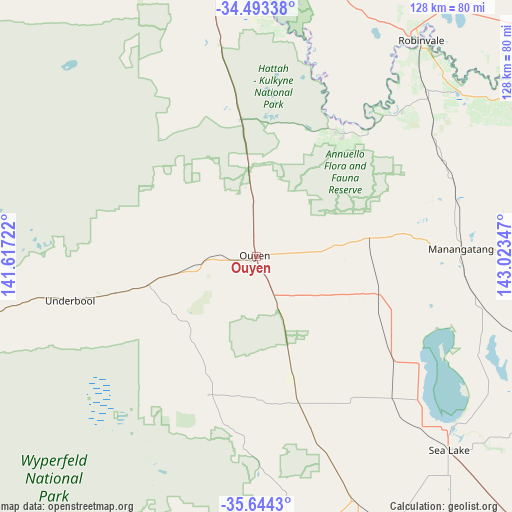
Ouyen GPS coordinates[2]
35° 4' 15.132" South, 142° 19' 13.224" East
| Map corner | latitude | longitude |
|---|---|---|
| Upper-left | -34.49338°, | 141.61722° |
| Center: | -35.07087°, | 142.32034° |
| Lower-right: | -35.6443°, | 143.02347° |
| Map W x H: | 128×128 km | = 79.5×79.5mi |
| max Lat: | -10.58257° ⇑72.7% North |
| Ouyen: | -35.07087° |
| min Lat: | ⇓27.3% South -43.31423° |
| min Long | Ouyen | max Long |
| 113.53327° | 142.32034° | 153.61246° |
| W 25.5%⇐ | ⇒74.5% E |
Elevation
Elevation of Ouyen is 56 m = 184 ft, and this is 66 m = 217 ft below average elevation for this country.
| Max E: |
1715 m = 5627 ft | 43.7% |
| Avg. | 122 m = 400 ft | |
| Ouyen | 56 m = 184 ft | |
Min E: |
-2 m = -7 ft | 56.3% |
See also: Australia elevation on elevation.city.
Geographical zone
Ouyen is located in South temperate zone (between Tropic of Capricorn and the Antarctic Circle). Distance of this Southern Tropic circle is 1293.6 km =803.8 mi to North.| Distance of | km | miles | from Ouyen |
|---|---|---|---|
| Equator | 3899.5 | 2423 | to North |
| Tropic Capricorn | 1293.6 | 803.8 | to North |
| Antarctic Circle | 3501.7 | 2175.9 | to South |
| South Pole | 6107.5 | 3795 | to South |


Nearby cities:
15 places around Ouyen: (largest is in red/bold)
• Birdwoodton
99.4 km =61.8 mi,  346°
346°
• Buronga
101 km =62.8 mi, 352°
• Cardross
86.8 km =53.9 mi, 348°
• Euston
67.4 km =41.9 mi,  35°
35°
• Gol Gol
100.1 km =62.2 mi, 354°
• Hopetoun
73.1 km =45.4 mi,  176°
176°
• Irymple
93.9 km =58.3 mi, 351°
• Mildura
99.5 km =61.8 mi, 351°
• Nichols Point
96 km =59.7 mi, 354°
• Nyah
96.8 km =60.1 mi,  96°
96°
• Nyah West
94.6 km =58.8 mi, 97°
• Rainbow
96.3 km =59.8 mi,  197°
197°
• Red Cliffs
85.5 km =53.1 mi, 351°
• Robinvale
68.1 km =42.3 mi, 37°
• Sea Lake
68 km =42.3 mi,  135°
135°
Sources, notices
• [Note1] Compared only with cities in Australia existing in our database
• [Src1] Map data: © OpenStreetMap contributors (CC-BY-SA)
• [Src2] Other city data from geonames.org with taken over terms of usage.
• [Src3] Geographical zone / Annual Mean Temperature by Robert A. Rohde @ Wikipedia
