Coomealla geodata
Coomealla (New South Wales) is a section of populated place; located in Australia in Australia/Sydney (GMT+11) time zone. With population of 808 people, there are 4127 cities with bigger population in this country. Compared to other cities in Australia, 60.8% of cities are located further ↑North; 74.8% of cities are located further →East and 60.7% of cities have lower elevation than Coomealla. Note1


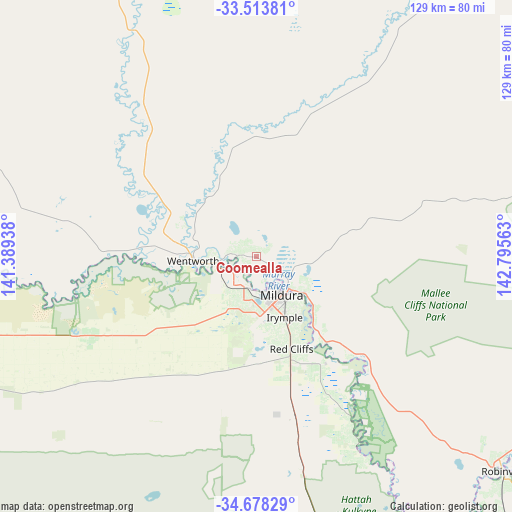
Coomealla GPS coordinates[2]
34° 5' 52.98" South, 142° 5' 33" East
| Map corner | latitude | longitude |
|---|---|---|
| Upper-left | -33.51381°, | 141.38938° |
| Center: | -34.09805°, | 142.0925° |
| Lower-right: | -34.67829°, | 142.79563° |
| Map W x H: | 129.5×129.5 km | = 80.5×80.5mi |
| max Lat: | -10.58257° ⇑60.8% North |
| Coomealla: | -34.09805° |
| min Lat: | ⇓39.2% South -43.31423° |
| min Long | Coomealla | max Long |
| 113.53327° | 142.0925° | 153.61246° |
| W 25.2%⇐ | ⇒74.8% E |
Elevation
Elevation of Coomealla is 66 m = 217 ft, and this is 56 m = 184 ft below average elevation for this country.
| Max E: |
1715 m = 5627 ft | 39.3% |
| Avg. | 122 m = 400 ft | |
| Coomealla | 66 m = 217 ft | |
Min E: |
-2 m = -7 ft | 60.7% |
See also: Australia elevation on elevation.city.
Geographical zone
Coomealla is located in South temperate zone (between Tropic of Capricorn and the Antarctic Circle). Distance of this Southern Tropic circle is 1185.4 km =736.6 mi to North.| Distance of | km | miles | from Coomealla |
|---|---|---|---|
| Equator | 3791.3 | 2355.8 | to North |
| Tropic Capricorn | 1185.4 | 736.6 | to North |
| Antarctic Circle | 3609.8 | 2243 | to South |
| South Pole | 6215.7 | 3862.3 | to South |


Nearby cities:
15 places around Coomealla: (largest is in red/bold)
• Birdwoodton
11.7 km =7.3 mi,  190°
190°
• Buronga
11 km =6.8 mi,  137°
137°
• Cardross
23.4 km =14.5 mi,  172°
172°
• Dareton
4.9 km =3 mi,  274°
274°
• Euston
79.9 km =49.6 mi,  131°
131°
• Gol Gol
14.6 km =9.1 mi, 125°
• Irymple
16.9 km =10.5 mi,  154°
154°
• Merbein
8.2 km =5.1 mi,  197°
197°
• Mildura
11.7 km =7.3 mi, 146°
• Nichols Point
16.9 km =10.5 mi, 138°
• Ouyen
110.2 km =68.5 mi, 169°
• Paringa
120.6 km =74.9 mi, 265°
• Red Cliffs
25.1 km =15.6 mi,  159°
159°
• Robinvale
82.5 km =51.3 mi, 130°
• Wentworth
16.5 km =10.3 mi, 266°
Sources, notices
• [Note1] Compared only with cities in Australia existing in our database
• [Src1] Map data: © OpenStreetMap contributors (CC-BY-SA)
• [Src2] Other city data from geonames.org with taken over terms of usage.
• [Src3] Geographical zone / Annual Mean Temperature by Robert A. Rohde @ Wikipedia
