Paringa geodata
Paringa (South Australia) is a section of populated place; located in Australia in Australia/Adelaide (GMT+10.5) time zone. With population of 1,129 people, there are 3664 cities with bigger population in this country. Compared to other cities in Australia, 61.1% of cities are located further ↑North; 75.5% of cities are located further →East and 52.8% of cities have lower elevation than Paringa. Note1


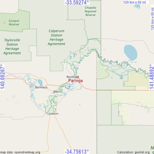
Paringa GPS coordinates[2]
34° 10' 35.184" South, 140° 47' 8.844" East
| Map corner | latitude | longitude |
|---|---|---|
| Upper-left | -33.59274°, | 140.08267° |
| Center: | -34.17644°, | 140.78579° |
| Lower-right: | -34.75613°, | 141.48892° |
| Map W x H: | 129.4×129.4 km | = 80.4×80.4mi |
| max Lat: | -10.58257° ⇑61.1% North |
| Paringa: | -34.17644° |
| min Lat: | ⇓38.9% South -43.31423° |
| min Long | Paringa | max Long |
| 113.53327° | 140.78579° | 153.61246° |
| W 24.5%⇐ | ⇒75.5% E |
Elevation
Elevation of Paringa is 49 m = 161 ft, and this is 73 m = 240 ft below average elevation for this country.
| Max E: |
1715 m = 5627 ft | 47.2% |
| Avg. | 122 m = 400 ft | |
| Paringa | 49 m = 161 ft | |
Min E: |
-2 m = -7 ft | 52.8% |
See also: Australia elevation on elevation.city.
Geographical zone
Paringa is located in South temperate zone (between Tropic of Capricorn and the Antarctic Circle). Distance of this Southern Tropic circle is 1194.1 km =742 mi to North.| Distance of | km | miles | from Paringa |
|---|---|---|---|
| Equator | 3800.1 | 2361.3 | to North |
| Tropic Capricorn | 1194.1 | 742 | to North |
| Antarctic Circle | 3601.1 | 2237.6 | to South |
| South Pole | 6207 | 3856.8 | to South |


Nearby cities:
15 places around Paringa: (largest is in red/bold)
• Barmera
31.1 km =19.3 mi,  253°
253°
• Berri
20.7 km =12.9 mi,  235°
235°
• Cadell
95.3 km =59.2 mi,  279°
279°
• Dareton
115.8 km =72 mi,  85°
85°
• Glossop
25.1 km =15.6 mi, 243°
• Kingston
40.6 km =25.2 mi,  261°
261°
• Loveday
34.5 km =21.4 mi, 249°
• Loxton
36.4 km =22.6 mi,  213°
213°
• Loxton North
30.7 km =19.1 mi, 209°
• Monash
21.8 km =13.5 mi, 251°
• Renmark
3.6 km =2.2 mi,  268°
268°
• Renmark North
8.8 km =5.5 mi,  310°
310°
• Renmark West
7.1 km =4.4 mi, 280°
• Waikerie
73.6 km =45.7 mi, 269°
• Wentworth
104 km =64.6 mi, 85°
Sources, notices
• [Note1] Compared only with cities in Australia existing in our database
• [Src1] Map data: © OpenStreetMap contributors (CC-BY-SA)
• [Src2] Other city data from geonames.org with taken over terms of usage.
• [Src3] Geographical zone / Annual Mean Temperature by Robert A. Rohde @ Wikipedia
