Cygnet geodata
Cygnet (Tasmania) is a populated place; located in Australia in Australia/Hobart (GMT+11) time zone. With population of 1,539 people, there are 3252 cities with bigger population in this country. Compared to other cities in Australia, 100% of cities are located further ↑North; 52.7% of cities are located further →East and 72.3% of cities have higher elevation than Cygnet. Note1


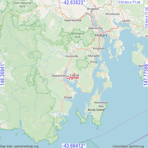
Cygnet GPS coordinates[2]
43° 9' 11.988" South, 147° 4' 21.108" East
| Map corner | latitude | longitude |
|---|---|---|
| Upper-left | -42.63823°, | 146.36941° |
| Center: | -43.15333°, | 147.07253° |
| Lower-right: | -43.66412°, | 147.77566° |
| Map W x H: | 114.1×114.1 km | = 70.9×70.9mi |
| max Lat: | -10.58257° ⇑100% North |
| Cygnet: | -43.15333° |
| min Lat: | ⇓0% South -43.31423° |
| min Long | Cygnet | max Long |
| 113.53327° | 147.07253° | 153.61246° |
| W 47.3%⇐ | ⇒52.7% E |
Elevation
Elevation of Cygnet is 21 m = 69 ft, and this is 101 m = 331 ft below average elevation for this country.
| Max E: |
1715 m = 5627 ft | 72.3% |
| Avg. | 122 m = 400 ft | |
| Cygnet | 21 m = 69 ft | |
Min E: |
-2 m = -7 ft | 27.7% |
See also: Australia elevation on elevation.city.
Geographical zone
Cygnet is located in South temperate zone (between Tropic of Capricorn and the Antarctic Circle). Distance of this Southern Tropic circle is 2192.3 km =1362.2 mi to North.| Distance of | km | miles | from Cygnet |
|---|---|---|---|
| Equator | 4798.2 | 2981.5 | to North |
| Tropic Capricorn | 2192.3 | 1362.2 | to North |
| Antarctic Circle | 2603 | 1617.4 | to South |
| South Pole | 5208.9 | 3236.7 | to South |


Nearby cities:
15 places around Cygnet: (largest is in red/bold)
• Blackmans Bay
25.9 km =16.1 mi,  49°
49°
• Dover
18.5 km =11.5 mi,  194°
194°
• Fern Tree
30.1 km =18.7 mi,  30°
30°
• Franklin
8.8 km =5.5 mi,  324°
324°
• Geeveston
12 km =7.5 mi,  264°
264°
• Glen Huon
15.9 km =9.9 mi,  327°
327°
• Howden
22.9 km =14.2 mi, 51°
• Huonville
13.7 km =8.5 mi,  351°
351°
• Kettering
14.4 km =8.9 mi,  77°
77°
• Kingston
27.2 km =16.9 mi,  43°
43°
• Kingston Beach
27.8 km =17.3 mi, 46°
• Margate
20.8 km =12.9 mi, 47°
• Mountain River
23.3 km =14.5 mi,  12°
12°
• Ranelagh
16.2 km =10.1 mi, 349°
• Snug
17.6 km =10.9 mi,  56°
56°
Sources, notices
• [Note1] Compared only with cities in Australia existing in our database
• [Src1] Map data: © OpenStreetMap contributors (CC-BY-SA)
• [Src2] Other city data from geonames.org with taken over terms of usage.
• [Src3] Geographical zone / Annual Mean Temperature by Robert A. Rohde @ Wikipedia
