Glen Huon geodata
Glen Huon (Tasmania) is a populated place; located in Australia in Australia/Hobart (GMT+11) time zone. With population of 652 people, there are 4434 cities with bigger population in this country. Compared to other cities in Australia, 99.9% of cities are located further ↑North; 53.3% of cities are located further →East and 67.8% of cities have lower elevation than Glen Huon. Note1


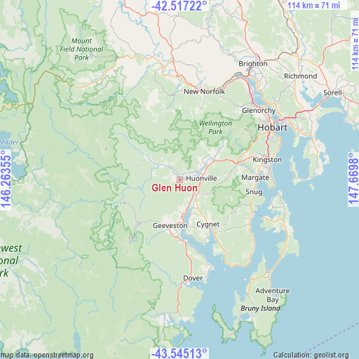
Glen Huon GPS coordinates[2]
43° 1' 59.988" South, 146° 58' 0.012" East
| Map corner | latitude | longitude |
|---|---|---|
| Upper-left | -42.51722°, | 146.26355° |
| Center: | -43.03333°, | 146.96667° |
| Lower-right: | -43.54513°, | 147.6698° |
| Map W x H: | 114.3×114.3 km | = 71×71mi |
| max Lat: | -10.58257° ⇑99.9% North |
| Glen Huon: | -43.03333° |
| min Lat: | ⇓0.1% South -43.31423° |
| min Long | Glen Huon | max Long |
| 113.53327° | 146.96667° | 153.61246° |
| W 46.7%⇐ | ⇒53.3% E |
Elevation
Elevation of Glen Huon is 92 m = 302 ft, and this is 30 m = 98 ft below average elevation for this country.
| Max E: |
1715 m = 5627 ft | 32.2% |
| Avg. | 122 m = 400 ft | |
| Glen Huon | 92 m = 302 ft | |
Min E: |
-2 m = -7 ft | 67.8% |
See also: Australia elevation on elevation.city.
Geographical zone
Glen Huon is located in South temperate zone (between Tropic of Capricorn and the Antarctic Circle). Distance of this Southern Tropic circle is 2178.9 km =1353.9 mi to North.| Distance of | km | miles | from Glen Huon |
|---|---|---|---|
| Equator | 4784.9 | 2973.2 | to North |
| Tropic Capricorn | 2178.9 | 1353.9 | to North |
| Antarctic Circle | 2616.3 | 1625.7 | to South |
| South Pole | 5222.2 | 3244.9 | to South |


Nearby cities:
15 places around Glen Huon: (largest is in red/bold)
• Blackmans Bay
28.7 km =17.8 mi,  83°
83°
• Collinsvale
28.3 km =17.6 mi,  41°
41°
• Cygnet
15.9 km =9.9 mi,  147°
147°
• Fern Tree
27.2 km =16.9 mi,  62°
62°
• Franklin
7.1 km =4.4 mi, 150°
• Geeveston
14.8 km =9.2 mi,  193°
193°
• Howden
26.6 km =16.5 mi,  88°
88°
• Huonville
6.6 km =4.1 mi, 87°
• Kettering
25 km =15.5 mi,  114°
114°
• Kingston
28.1 km =17.5 mi, 76°
• Lachlan
23.2 km =14.4 mi,  16°
16°
• Margate
24.1 km =15 mi, 88°
• Mountain River
16.5 km =10.3 mi, 55°
• Ranelagh
6.3 km =3.9 mi,  65°
65°
• Snug
23.7 km =14.7 mi,  99°
99°
Sources, notices
• [Note1] Compared only with cities in Australia existing in our database
• [Src1] Map data: © OpenStreetMap contributors (CC-BY-SA)
• [Src2] Other city data from geonames.org with taken over terms of usage.
• [Src3] Geographical zone / Annual Mean Temperature by Robert A. Rohde @ Wikipedia
