Portarlington geodata
Portarlington (Victoria) is a populated place; located in Australia in Australia/Melbourne (GMT+11) time zone. With population of 3,490 people, there are 1992 cities with bigger population in this country. Compared to other cities in Australia, 93% of cities are located further ↑North; 69.7% of cities are located further →East and 64.8% of cities have higher elevation than Portarlington. Note1


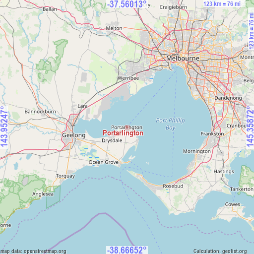
Portarlington GPS coordinates[2]
38° 6' 55.512" South, 144° 39' 20.124" East
| Map corner | latitude | longitude |
|---|---|---|
| Upper-left | -37.56013°, | 143.95247° |
| Center: | -38.11542°, | 144.65559° |
| Lower-right: | -38.66652°, | 145.35872° |
| Map W x H: | 123×123 km | = 76.4×76.4mi |
| max Lat: | -10.58257° ⇑93% North |
| Portarlington: | -38.11542° |
| min Lat: | ⇓7% South -43.31423° |
| min Long | Portarlington | max Long |
| 113.53327° | 144.65559° | 153.61246° |
| W 30.3%⇐ | ⇒69.7% E |
Elevation
Elevation of Portarlington is 27 m = 89 ft, and this is 95 m = 312 ft below average elevation for this country.
| Max E: |
1715 m = 5627 ft | 64.8% |
| Avg. | 122 m = 400 ft | |
| Portarlington | 27 m = 89 ft | |
Min E: |
-2 m = -7 ft | 35.2% |
See also: Australia elevation on elevation.city.
Geographical zone
Portarlington is located in South temperate zone (between Tropic of Capricorn and the Antarctic Circle). Distance of this Southern Tropic circle is 1632.1 km =1014.1 mi to North.| Distance of | km | miles | from Portarlington |
|---|---|---|---|
| Equator | 4238 | 2633.4 | to North |
| Tropic Capricorn | 1632.1 | 1014.1 | to North |
| Antarctic Circle | 3163.1 | 1965.5 | to South |
| South Pole | 5769 | 3584.7 | to South |


Nearby cities:
15 places around Portarlington: (largest is in red/bold)
• Barwon Heads
22.9 km =14.2 mi,  219°
219°
• Clifton Springs
9.9 km =6.2 mi,  242°
242°
• Drysdale
9.8 km =6.1 mi,  229°
229°
• Indented Head
5.9 km =3.7 mi,  121°
121°
• Leopold
18.4 km =11.4 mi, 243°
• Little River
21.4 km =13.3 mi,  320°
320°
• Moolap
20.8 km =12.9 mi,  248°
248°
• Newcomb
23.5 km =14.6 mi,  256°
256°
• Ocean Grove
19.8 km =12.3 mi, 216°
• Point Cook
23.8 km =14.8 mi,  20°
20°
• Point Lonsdale
18.9 km =11.7 mi,  192°
192°
• Queenscliff
17 km =10.6 mi,  178°
178°
• Saint Leonards
8.2 km =5.1 mi,  138°
138°
• Wallington
17.6 km =10.9 mi, 225°
• Werribee South
19.4 km =12.1 mi, 15°
Sources, notices
• [Note1] Compared only with cities in Australia existing in our database
• [Src1] Map data: © OpenStreetMap contributors (CC-BY-SA)
• [Src2] Other city data from geonames.org with taken over terms of usage.
• [Src3] Geographical zone / Annual Mean Temperature by Robert A. Rohde @ Wikipedia
