Indented Head geodata
Indented Head (Victoria) is a populated place; located in Australia in Australia/Melbourne (GMT+11) time zone. With population of 1,105 people, there are 3690 cities with bigger population in this country. Compared to other cities in Australia, 93.3% of cities are located further ↑North; 69.5% of cities are located further →East and 86.8% of cities have higher elevation than Indented Head. Note1


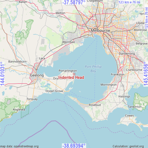
Indented Head GPS coordinates[2]
38° 8' 34.98" South, 144° 42' 48.348" East
| Map corner | latitude | longitude |
|---|---|---|
| Upper-left | -37.58797°, | 144.01031° |
| Center: | -38.14305°, | 144.71343° |
| Lower-right: | -38.69394°, | 145.41656° |
| Map W x H: | 123×123 km | = 76.4×76.4mi |
| max Lat: | -10.58257° ⇑93.3% North |
| Indented Head: | -38.14305° |
| min Lat: | ⇓6.7% South -43.31423° |
| min Long | Indented Head | max Long |
| 113.53327° | 144.71343° | 153.61246° |
| W 30.5%⇐ | ⇒69.5% E |
Elevation
Elevation of Indented Head is 11 m = 36 ft, and this is 111 m = 364 ft below average elevation for this country.
| Max E: |
1715 m = 5627 ft | 86.8% |
| Avg. | 122 m = 400 ft | |
| Indented Head | 11 m = 36 ft | |
Min E: |
-2 m = -7 ft | 13.2% |
See also: Australia elevation on elevation.city.
Geographical zone
Indented Head is located in South temperate zone (between Tropic of Capricorn and the Antarctic Circle). Distance of this Southern Tropic circle is 1635.2 km =1016.1 mi to North.| Distance of | km | miles | from Indented Head |
|---|---|---|---|
| Equator | 4241.1 | 2635.3 | to North |
| Tropic Capricorn | 1635.2 | 1016.1 | to North |
| Antarctic Circle | 3160.1 | 1963.6 | to South |
| South Pole | 5766 | 3582.8 | to South |


Nearby cities:
15 places around Indented Head: (largest is in red/bold)
• Barwon Heads
24.5 km =15.2 mi,  233°
233°
• Blairgowrie
24.9 km =15.5 mi,  166°
166°
• Clifton Springs
13.9 km =8.6 mi,  263°
263°
• Drysdale
13 km =8.1 mi, 255°
• Leopold
22.1 km =13.7 mi, 256°
• Moolap
24.9 km =15.5 mi, 259°
• Ocean Grove
21.2 km =13.2 mi, 233°
• Point Cook
25.6 km =15.9 mi,  7°
7°
• Point Lonsdale
17.8 km =11.1 mi,  210°
210°
• Portarlington
5.9 km =3.7 mi,  301°
301°
• Queenscliff
14.6 km =9.1 mi,  197°
197°
• Saint Leonards
3.1 km =1.9 mi, 172°
• Sorrento
22 km =13.7 mi, 173°
• Wallington
19.9 km =12.4 mi,  242°
242°
• Werribee South
21.7 km =13.5 mi,  0°
0°
Sources, notices
• [Note1] Compared only with cities in Australia existing in our database
• [Src1] Map data: © OpenStreetMap contributors (CC-BY-SA)
• [Src2] Other city data from geonames.org with taken over terms of usage.
• [Src3] Geographical zone / Annual Mean Temperature by Robert A. Rohde @ Wikipedia
