Peachester geodata
Peachester (Queensland) is a section of populated place; located in Australia in Australia/Brisbane (GMT+10) time zone. With population of 1,350 people, there are 3417 cities with bigger population in this country. Compared to other cities in Australia, 85.8% of cities are located further ↓South; 88.3% of cities are located further ←West and 79.1% of cities have lower elevation than Peachester. Note1


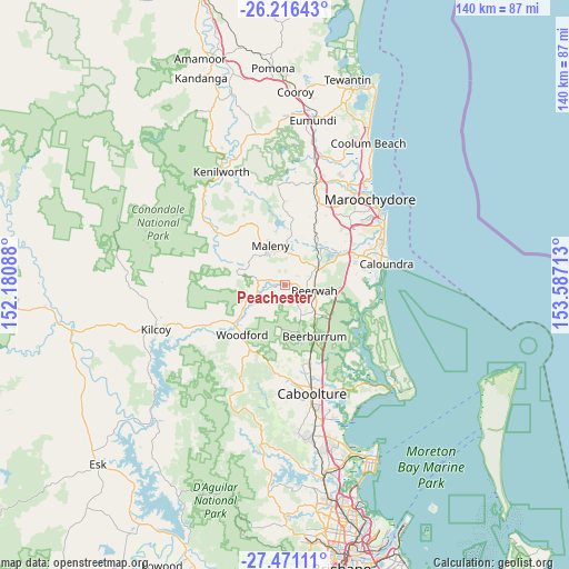
Peachester GPS coordinates[2]
26° 50' 43.836" South, 152° 53' 2.4" East
| Map corner | latitude | longitude |
|---|---|---|
| Upper-left | -26.21643°, | 152.18088° |
| Center: | -26.84551°, | 152.884° |
| Lower-right: | -27.47111°, | 153.58713° |
| Map W x H: | 139.5×139.5 km | = 86.7×86.7mi |
| max Lat: | -10.58257° ⇑14.2% North |
| Peachester: | -26.84551° |
| min Lat: | ⇓85.8% South -43.31423° |
| min Long | Peachester | max Long |
| 113.53327° | 152.884° | 153.61246° |
| W 88.3%⇐ | ⇒11.7% E |
Elevation
Elevation of Peachester is 168 m = 551 ft, and this is 46 m = 151 ft above average elevation for this country.
| Max E: |
1715 m = 5627 ft | 20.9% |
| Peachester | 168 m 551 ft | |
| Avg. | 122 m = 400 ft | |
Min E: |
-2 m = -7 ft | 79.1% |
See also: Australia elevation on elevation.city.
Geographical zone
Peachester is located in South temperate zone (between Tropic of Capricorn and the Antarctic Circle). Distance of this Southern Tropic circle is 379 km =235.5 mi to North.| Distance of | km | miles | from Peachester |
|---|---|---|---|
| Equator | 2984.9 | 1854.7 | to North |
| Tropic Capricorn | 379 | 235.5 | to North |
| Antarctic Circle | 4416.2 | 2744.1 | to South |
| South Pole | 7022.1 | 4363.3 | to South |


Nearby cities:
15 places around Peachester: (largest is in red/bold)
• Beerburrum
14.3 km =8.9 mi,  150°
150°
• Beerwah
7.8 km =4.8 mi,  100°
100°
• D’Aguilar
17.4 km =10.8 mi,  208°
208°
• Eudlo
14.6 km =9.1 mi,  28°
28°
• Glass House Mountains
9 km =5.6 mi,  130°
130°
• Glenview
15.8 km =9.8 mi,  56°
56°
• Hunchy
18.6 km =11.6 mi,  8°
8°
• Ilkley
17 km =10.6 mi,  41°
41°
• Landsborough
8.8 km =5.5 mi, 60°
• Maleny
10.1 km =6.3 mi,  340°
340°
• Montville
18 km =11.2 mi,  359°
359°
• North Maleny
10.7 km =6.6 mi,  346°
346°
• Reesville
13.5 km =8.4 mi,  315°
315°
• Witta
17.5 km =10.9 mi, 337°
• Woodford
15.9 km =9.9 mi,  221°
221°
Sources, notices
• [Note1] Compared only with cities in Australia existing in our database
• [Src1] Map data: © OpenStreetMap contributors (CC-BY-SA)
• [Src2] Other city data from geonames.org with taken over terms of usage.
• [Src3] Geographical zone / Annual Mean Temperature by Robert A. Rohde @ Wikipedia
