Maleny geodata
Maleny (Queensland) is a populated place; located in Australia in Australia/Brisbane (GMT+10) time zone. With population of 3,696 people, there are 1921 cities with bigger population in this country. Compared to other cities in Australia, 86.2% of cities are located further ↓South; 87.6% of cities are located further ←West and 91.2% of cities have lower elevation than Maleny. Note1


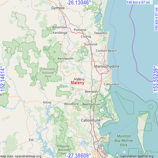
Maleny GPS coordinates[2]
26° 45' 36.036" South, 152° 50' 57.336" East
| Map corner | latitude | longitude |
|---|---|---|
| Upper-left | -26.13046°, | 152.14614° |
| Center: | -26.76001°, | 152.84926° |
| Lower-right: | -27.38609°, | 153.55239° |
| Map W x H: | 139.6×139.6 km | = 86.7×86.7mi |
| max Lat: | -10.58257° ⇑13.8% North |
| Maleny: | -26.76001° |
| min Lat: | ⇓86.2% South -43.31423° |
| min Long | Maleny | max Long |
| 113.53327° | 152.84926° | 153.61246° |
| W 87.6%⇐ | ⇒12.4% E |
Elevation
Elevation of Maleny is 418 m = 1371 ft, and this is 296 m = 971 ft above average elevation for this country.
| Max E: |
1715 m = 5627 ft | 8.8% |
| Maleny | 418 m 1371 ft | |
| Avg. | 122 m = 400 ft | |
Min E: |
-2 m = -7 ft | 91.2% |
See also: Australia elevation on elevation.city.
Geographical zone
Maleny is located in South temperate zone (between Tropic of Capricorn and the Antarctic Circle). Distance of this Southern Tropic circle is 369.5 km =229.6 mi to North.| Distance of | km | miles | from Maleny |
|---|---|---|---|
| Equator | 2975.4 | 1848.8 | to North |
| Tropic Capricorn | 369.5 | 229.6 | to North |
| Antarctic Circle | 4425.7 | 2750 | to South |
| South Pole | 7031.6 | 4369.2 | to South |


Nearby cities:
15 places around Maleny: (largest is in red/bold)
• Conondale
13.1 km =8.1 mi,  281°
281°
• Dulong
15.1 km =9.4 mi,  21°
21°
• Eudlo
10.9 km =6.8 mi,  71°
71°
• Flaxton
11.5 km =7.1 mi,  7°
7°
• Hunchy
10.8 km =6.7 mi,  34°
34°
• Ilkley
15.1 km =9.4 mi,  77°
77°
• Landsborough
12.2 km =7.6 mi,  115°
115°
• Mapleton
15.2 km =9.4 mi, 6°
• Montville
9.2 km =5.7 mi, 21°
• North Maleny
1.3 km =0.8 mi,  45°
45°
• Palmwoods
13.9 km =8.6 mi, 53°
• Peachester
10.1 km =6.3 mi,  160°
160°
• Reesville
6.1 km =3.8 mi,  270°
270°
• West Woombye
12.9 km =8 mi,  36°
36°
• Witta
7.4 km =4.6 mi,  334°
334°
Sources, notices
• [Note1] Compared only with cities in Australia existing in our database
• [Src1] Map data: © OpenStreetMap contributors (CC-BY-SA)
• [Src2] Other city data from geonames.org with taken over terms of usage.
• [Src3] Geographical zone / Annual Mean Temperature by Robert A. Rohde @ Wikipedia
