Landsborough geodata
Landsborough (Queensland) is a section of populated place; located in Australia in Australia/Brisbane (GMT+10) time zone. With population of 3,834 people, there are 1854 cities with bigger population in this country. Compared to other cities in Australia, 85.9% of cities are located further ↓South; 89.9% of cities are located further ←West and 52% of cities have lower elevation than Landsborough. Note1


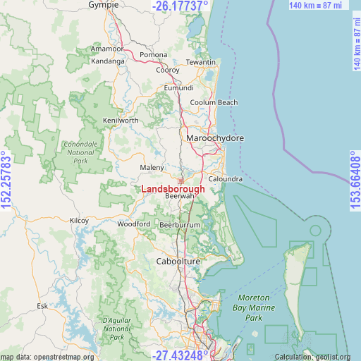
Landsborough GPS coordinates[2]
26° 48' 23.976" South, 152° 57' 39.42" East
| Map corner | latitude | longitude |
|---|---|---|
| Upper-left | -26.17737°, | 152.25783° |
| Center: | -26.80666°, | 152.96095° |
| Lower-right: | -27.43248°, | 153.66408° |
| Map W x H: | 139.6×139.6 km | = 86.7×86.7mi |
| max Lat: | -10.58257° ⇑14.1% North |
| Landsborough: | -26.80666° |
| min Lat: | ⇓85.9% South -43.31423° |
| min Long | Landsborough | max Long |
| 113.53327° | 152.96095° | 153.61246° |
| W 89.9%⇐ | ⇒10.1% E |
Elevation
Elevation of Landsborough is 48 m = 157 ft, and this is 74 m = 243 ft below average elevation for this country.
| Max E: |
1715 m = 5627 ft | 48% |
| Avg. | 122 m = 400 ft | |
| Landsborough | 48 m = 157 ft | |
Min E: |
-2 m = -7 ft | 52% |
See also: Australia elevation on elevation.city.
Geographical zone
Landsborough is located in South temperate zone (between Tropic of Capricorn and the Antarctic Circle). Distance of this Southern Tropic circle is 374.7 km =232.8 mi to North.| Distance of | km | miles | from Landsborough |
|---|---|---|---|
| Equator | 2980.6 | 1852.1 | to North |
| Tropic Capricorn | 374.7 | 232.8 | to North |
| Antarctic Circle | 4420.6 | 2746.8 | to South |
| South Pole | 7026.4 | 4366 | to South |


Nearby cities:
15 places around Landsborough: (largest is in red/bold)
• Beerwah
5.8 km =3.6 mi,  179°
179°
• Eudlo
8.6 km =5.3 mi,  355°
355°
• Forest Glen
13.8 km =8.6 mi,  18°
18°
• Glass House Mountains
10.1 km =6.3 mi, 184°
• Glenview
7.1 km =4.4 mi,  51°
51°
• Ilkley
9.2 km =5.7 mi, 23°
• Little Mountain
13.3 km =8.3 mi,  79°
79°
• Maleny
12.2 km =7.6 mi,  295°
295°
• Meridan Plains
10.7 km =6.6 mi,  69°
69°
• North Maleny
11.9 km =7.4 mi, 300°
• Palmview
11.9 km =7.4 mi,  55°
55°
• Palmwoods
13.4 km =8.3 mi,  0°
0°
• Peachester
8.8 km =5.5 mi,  240°
240°
• Sippy Downs
13.6 km =8.5 mi,  43°
43°
• Tanawha
11.9 km =7.4 mi, 35°
Sources, notices
• [Note1] Compared only with cities in Australia existing in our database
• [Src1] Map data: © OpenStreetMap contributors (CC-BY-SA)
• [Src2] Other city data from geonames.org with taken over terms of usage.
• [Src3] Geographical zone / Annual Mean Temperature by Robert A. Rohde @ Wikipedia
