Orford geodata
Orford (Tasmania) is a populated place; located in Australia in Australia/Hobart (GMT+11) time zone. With population of 616 people, there are 4531 cities with bigger population in this country. Compared to other cities in Australia, 98.2% of cities are located further ↑North; 50.8% of cities are located further ←West and 91.8% of cities have higher elevation than Orford. Note1


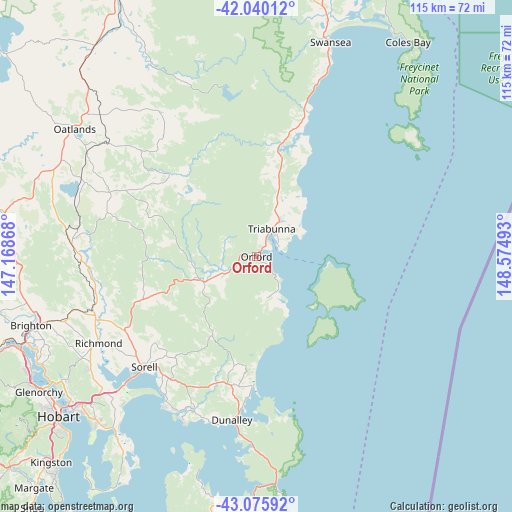
Orford GPS coordinates[2]
42° 33' 36.612" South, 147° 52' 18.48" East
| Map corner | latitude | longitude |
|---|---|---|
| Upper-left | -42.04012°, | 147.16868° |
| Center: | -42.56017°, | 147.8718° |
| Lower-right: | -43.07592°, | 148.57493° |
| Map W x H: | 115.2×115.2 km | = 71.6×71.6mi |
| max Lat: | -10.58257° ⇑98.2% North |
| Orford: | -42.56017° |
| min Lat: | ⇓1.8% South -43.31423° |
| min Long | Orford | max Long |
| 113.53327° | 147.8718° | 153.61246° |
| W 50.8%⇐ | ⇒49.2% E |
Elevation
Elevation of Orford is 8 m = 26 ft, and this is 114 m = 374 ft below average elevation for this country.
| Max E: |
1715 m = 5627 ft | 91.8% |
| Avg. | 122 m = 400 ft | |
| Orford | 8 m = 26 ft | |
Min E: |
-2 m = -7 ft | 8.2% |
See also: Australia elevation on elevation.city.
Geographical zone
Orford is located in South temperate zone (between Tropic of Capricorn and the Antarctic Circle). Distance of this Southern Tropic circle is 2126.3 km =1321.2 mi to North.| Distance of | km | miles | from Orford |
|---|---|---|---|
| Equator | 4732.2 | 2940.5 | to North |
| Tropic Capricorn | 2126.3 | 1321.2 | to North |
| Antarctic Circle | 2668.9 | 1658.4 | to South |
| South Pole | 5274.8 | 3277.6 | to South |


Nearby cities:
15 places around Orford: (largest is in red/bold)
• Acton Park
47.5 km =29.5 mi,  221°
221°
• Cambridge
45.9 km =28.5 mi,  228°
228°
• Campania
38.5 km =23.9 mi,  252°
252°
• Carlton
37.9 km =23.5 mi,  207°
207°
• Dodges Ferry
38.4 km =23.9 mi, 212°
• Forcett
33 km =20.5 mi, 216°
• Lauderdale
50.3 km =31.3 mi, 218°
• Lewisham
36.8 km =22.9 mi, 214°
• Midway Point
38.3 km =23.8 mi, 227°
• Oatlands
50.3 km =31.3 mi,  304°
304°
• Primrose Sands
39.8 km =24.7 mi,  204°
204°
• Richmond
40.5 km =25.2 mi,  241°
241°
• Seven Mile Beach
44.7 km =27.8 mi, 222°
• Sorell
35.3 km =21.9 mi, 225°
• Triabunna
6.6 km =4.1 mi,  29°
29°
Sources, notices
• [Note1] Compared only with cities in Australia existing in our database
• [Src1] Map data: © OpenStreetMap contributors (CC-BY-SA)
• [Src2] Other city data from geonames.org with taken over terms of usage.
• [Src3] Geographical zone / Annual Mean Temperature by Robert A. Rohde @ Wikipedia
