Oatlands geodata
Oatlands (Tasmania) is a populated place; located in Australia in Australia/Hobart (GMT+11) time zone. With population of 669 people, there are 4384 cities with bigger population in this country. Compared to other cities in Australia, 98.2% of cities are located further ↑North; 50.4% of cities are located further →East and 91.1% of cities have lower elevation than Oatlands. Note1


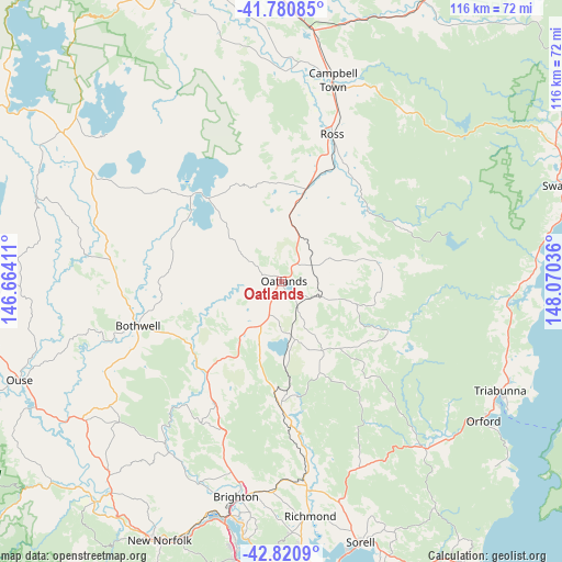
Oatlands GPS coordinates[2]
42° 18' 10.872" South, 147° 22' 2.028" East
| Map corner | latitude | longitude |
|---|---|---|
| Upper-left | -41.78085°, | 146.66411° |
| Center: | -42.30302°, | 147.36723° |
| Lower-right: | -42.8209°, | 148.07036° |
| Map W x H: | 115.6×115.6 km | = 71.8×71.8mi |
| max Lat: | -10.58257° ⇑98.2% North |
| Oatlands: | -42.30302° |
| min Lat: | ⇓1.8% South -43.31423° |
| min Long | Oatlands | max Long |
| 113.53327° | 147.36723° | 153.61246° |
| W 49.6%⇐ | ⇒50.4% E |
Elevation
Elevation of Oatlands is 417 m = 1368 ft, and this is 295 m = 968 ft above average elevation for this country.
| Max E: |
1715 m = 5627 ft | 8.9% |
| Oatlands | 417 m 1368 ft | |
| Avg. | 122 m = 400 ft | |
Min E: |
-2 m = -7 ft | 91.1% |
See also: Australia elevation on elevation.city.
Geographical zone
Oatlands is located in South temperate zone (between Tropic of Capricorn and the Antarctic Circle). Distance of this Southern Tropic circle is 2097.7 km =1303.4 mi to North.| Distance of | km | miles | from Oatlands |
|---|---|---|---|
| Equator | 4703.7 | 2922.7 | to North |
| Tropic Capricorn | 2097.7 | 1303.4 | to North |
| Antarctic Circle | 2697.5 | 1676.1 | to South |
| South Pole | 5303.4 | 3295.4 | to South |


Nearby cities:
15 places around Oatlands: (largest is in red/bold)
• Austins Ferry
52.4 km =32.6 mi,  190°
190°
• Bagdad
38.2 km =23.7 mi,  197°
197°
• Bridgewater
49.6 km =30.8 mi, 193°
• Brighton
45.1 km =28 mi, 192°
• Campania
40.5 km =25.2 mi,  173°
173°
• Campbell Town
43.2 km =26.8 mi,  13°
13°
• Dromedary
50.6 km =31.4 mi, 198°
• Gagebrook
50.1 km =31.1 mi, 189°
• Granton
51.2 km =31.8 mi, 192°
• Herdsmans Cove
50.5 km =31.4 mi, 189°
• Honeywood
47.6 km =29.6 mi, 188°
• Orford
50.3 km =31.3 mi,  124°
124°
• Pontville
43.5 km =27 mi, 190°
• Richmond
48.4 km =30.1 mi, 173°
• Triabunna
50.2 km =31.2 mi, 117°
Sources, notices
• [Note1] Compared only with cities in Australia existing in our database
• [Src1] Map data: © OpenStreetMap contributors (CC-BY-SA)
• [Src2] Other city data from geonames.org with taken over terms of usage.
• [Src3] Geographical zone / Annual Mean Temperature by Robert A. Rohde @ Wikipedia
