Oakey geodata
Oakey (Queensland) is a populated place; located in Australia in Australia/Brisbane (GMT+10) time zone. With population of 4,724 people, there are 1561 cities with bigger population in this country. Compared to other cities in Australia, 83.3% of cities are located further ↓South; 80.7% of cities are located further ←West and 90.7% of cities have lower elevation than Oakey. Note1


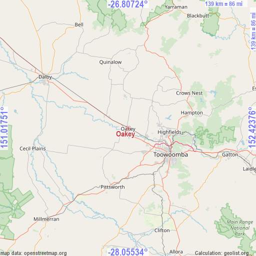
Oakey GPS coordinates[2]
27° 25' 58.98" South, 151° 43' 14.268" East
| Map corner | latitude | longitude |
|---|---|---|
| Upper-left | -26.80724°, | 151.01751° |
| Center: | -27.43305°, | 151.72063° |
| Lower-right: | -28.05534°, | 152.42376° |
| Map W x H: | 138.8×138.8 km | = 86.2×86.2mi |
| max Lat: | -10.58257° ⇑16.7% North |
| Oakey: | -27.43305° |
| min Lat: | ⇓83.3% South -43.31423° |
| min Long | Oakey | max Long |
| 113.53327° | 151.72063° | 153.61246° |
| W 80.7%⇐ | ⇒19.3% E |
Elevation
Elevation of Oakey is 403 m = 1322 ft, and this is 281 m = 922 ft above average elevation for this country.
| Max E: |
1715 m = 5627 ft | 9.3% |
| Oakey | 403 m 1322 ft | |
| Avg. | 122 m = 400 ft | |
Min E: |
-2 m = -7 ft | 90.7% |
See also: Australia elevation on elevation.city.
Geographical zone
Oakey is located in South temperate zone (between Tropic of Capricorn and the Antarctic Circle). Distance of this Southern Tropic circle is 444.4 km =276.1 mi to North.| Distance of | km | miles | from Oakey |
|---|---|---|---|
| Equator | 3050.3 | 1895.4 | to North |
| Tropic Capricorn | 444.4 | 276.1 | to North |
| Antarctic Circle | 4350.9 | 2703.5 | to South |
| South Pole | 6956.8 | 4322.8 | to South |


Nearby cities:
15 places around Oakey: (largest is in red/bold)
• Blue Mountain Heights
24.5 km =15.2 mi,  108°
108°
• Cotswold Hills
19.9 km =12.4 mi,  119°
119°
• Cranley
21.9 km =13.6 mi, 114°
• Glenvale
22.7 km =14.1 mi,  131°
131°
• Goombungee
19 km =11.8 mi,  42°
42°
• Gowrie Junction
17 km =10.6 mi, 109°
• Highfields
23.3 km =14.5 mi,  98°
98°
• Kingsthorpe
10.4 km =6.5 mi, 117°
• Kleinton
22.6 km =14 mi,  90°
90°
• Meringandan West
16.6 km =10.3 mi,  83°
83°
• Newtown
25 km =15.5 mi, 123°
• Rockville
24.3 km =15.1 mi, 118°
• Torrington
20.5 km =12.7 mi, 126°
• Wilsonton
22.9 km =14.2 mi, 122°
• Wilsonton Heights
22.9 km =14.2 mi, 118°
Sources, notices
• [Note1] Compared only with cities in Australia existing in our database
• [Src1] Map data: © OpenStreetMap contributors (CC-BY-SA)
• [Src2] Other city data from geonames.org with taken over terms of usage.
• [Src3] Geographical zone / Annual Mean Temperature by Robert A. Rohde @ Wikipedia
