Nobby geodata
Nobby (Queensland) is a populated place; located in Australia in Australia/Brisbane (GMT+10) time zone. With population of 548 people, there are 4711 cities with bigger population in this country. Compared to other cities in Australia, 77% of cities are located further ↓South; 81.8% of cities are located further ←West and 93.1% of cities have lower elevation than Nobby. Note1


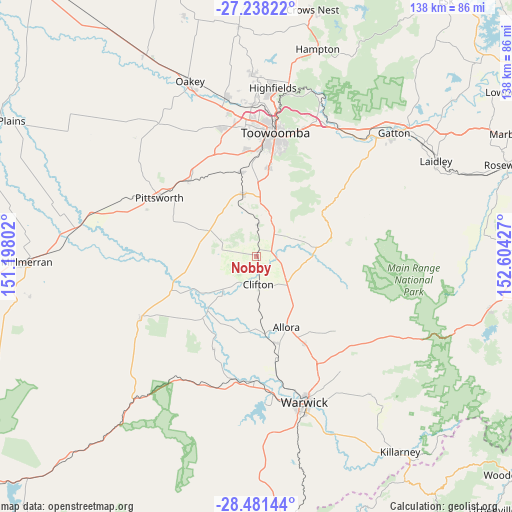
Nobby GPS coordinates[2]
27° 51' 41.796" South, 151° 54' 4.104" East
| Map corner | latitude | longitude |
|---|---|---|
| Upper-left | -27.23822°, | 151.19802° |
| Center: | -27.86161°, | 151.90114° |
| Lower-right: | -28.48144°, | 152.60427° |
| Map W x H: | 138.2×138.2 km | = 85.9×85.9mi |
| max Lat: | -10.58257° ⇑23% North |
| Nobby: | -27.86161° |
| min Lat: | ⇓77% South -43.31423° |
| min Long | Nobby | max Long |
| 113.53327° | 151.90114° | 153.61246° |
| W 81.8%⇐ | ⇒18.2% E |
Elevation
Elevation of Nobby is 477 m = 1565 ft, and this is 355 m = 1165 ft above average elevation for this country.
| Max E: |
1715 m = 5627 ft | 6.9% |
| Nobby | 477 m 1565 ft | |
| Avg. | 122 m = 400 ft | |
Min E: |
-2 m = -7 ft | 93.1% |
See also: Australia elevation on elevation.city.
Geographical zone
Nobby is located in South temperate zone (between Tropic of Capricorn and the Antarctic Circle). Distance of this Southern Tropic circle is 492 km =305.7 mi to North.| Distance of | km | miles | from Nobby |
|---|---|---|---|
| Equator | 3097.9 | 1924.9 | to North |
| Tropic Capricorn | 492 | 305.7 | to North |
| Antarctic Circle | 4303.3 | 2673.9 | to South |
| South Pole | 6909.1 | 4293.1 | to South |


Nearby cities:
15 places around Nobby: (largest is in red/bold)
• Allora
20.8 km =12.9 mi,  157°
157°
• Cambooya
16.8 km =10.4 mi,  346°
346°
• Clifton
8 km =5 mi,  176°
176°
• Darling Heights
29.6 km =18.4 mi,  5°
5°
• Drayton
29.1 km =18.1 mi,  359°
359°
• Greenmount
8.4 km =5.2 mi, 359°
• Hodgson Vale
22.1 km =13.7 mi, 8°
• Kearneys Spring
28.8 km =17.9 mi, 7°
• Middle Ridge
29 km =18 mi, 12°
• Pittsworth
30.8 km =19.1 mi,  301°
301°
• Preston
23.9 km =14.9 mi,  20°
20°
• Southbrook
26.9 km =16.7 mi,  317°
317°
• Top Camp
25.4 km =15.8 mi, 8°
• Westbrook
27.4 km =17 mi, 352°
• Wyreema
23.3 km =14.5 mi, 348°
Sources, notices
• [Note1] Compared only with cities in Australia existing in our database
• [Src1] Map data: © OpenStreetMap contributors (CC-BY-SA)
• [Src2] Other city data from geonames.org with taken over terms of usage.
• [Src3] Geographical zone / Annual Mean Temperature by Robert A. Rohde @ Wikipedia
