Bunyip geodata
Bunyip (Victoria) is a section of populated place; located in Australia in Australia/Melbourne (GMT+11) time zone. With population of 2,416 people, there are 2624 cities with bigger population in this country. Compared to other cities in Australia, 92.7% of cities are located further ↑North; 58.5% of cities are located further →East and 51.1% of cities have lower elevation than Bunyip. Note1


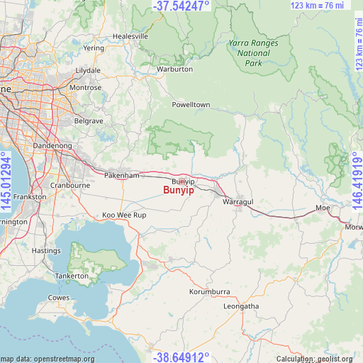
Bunyip GPS coordinates[2]
38° 5' 52.404" South, 145° 42' 57.816" East
| Map corner | latitude | longitude |
|---|---|---|
| Upper-left | -37.54247°, | 145.01294° |
| Center: | -38.09789°, | 145.71606° |
| Lower-right: | -38.64912°, | 146.41919° |
| Map W x H: | 123×123 km | = 76.4×76.4mi |
| max Lat: | -10.58257° ⇑92.7% North |
| Bunyip: | -38.09789° |
| min Lat: | ⇓7.3% South -43.31423° |
| min Long | Bunyip | max Long |
| 113.53327° | 145.71606° | 153.61246° |
| W 41.5%⇐ | ⇒58.5% E |
Elevation
Elevation of Bunyip is 47 m = 154 ft, and this is 75 m = 246 ft below average elevation for this country.
| Max E: |
1715 m = 5627 ft | 48.9% |
| Avg. | 122 m = 400 ft | |
| Bunyip | 47 m = 154 ft | |
Min E: |
-2 m = -7 ft | 51.1% |
See also: Australia elevation on elevation.city.
Geographical zone
Bunyip is located in South temperate zone (between Tropic of Capricorn and the Antarctic Circle). Distance of this Southern Tropic circle is 1630.2 km =1013 mi to North.| Distance of | km | miles | from Bunyip |
|---|---|---|---|
| Equator | 4236.1 | 2632.2 | to North |
| Tropic Capricorn | 1630.2 | 1013 | to North |
| Antarctic Circle | 3165.1 | 1966.7 | to South |
| South Pole | 5771 | 3585.9 | to South |


Nearby cities:
15 places around Bunyip: (largest is in red/bold)
• Buln Buln
19 km =11.8 mi,  90°
90°
• Drouin
13.2 km =8.2 mi,  109°
109°
• Garfield
3.7 km =2.3 mi,  283°
283°
• Gembrook
21.4 km =13.3 mi,  318°
318°
• Koo-Wee-Rup
22.7 km =14.1 mi,  240°
240°
• Lang Lang
23 km =14.3 mi,  215°
215°
• Longwarry
4.9 km =3 mi, 109°
• Maryknoll
12.7 km =7.9 mi,  302°
302°
• Nar Nar Goon
12.9 km =8 mi, 277°
• Nar Nar Goon North
15.9 km =9.9 mi, 304°
• Neerim South
22.7 km =14.1 mi,  66°
66°
• Nyora
26.5 km =16.5 mi,  188°
188°
• Pakenham
21.4 km =13.3 mi, 278°
• Pakenham Upper
19.7 km =12.2 mi, 297°
• Warragul
20 km =12.4 mi, 109°
Sources, notices
• [Note1] Compared only with cities in Australia existing in our database
• [Src1] Map data: © OpenStreetMap contributors (CC-BY-SA)
• [Src2] Other city data from geonames.org with taken over terms of usage.
• [Src3] Geographical zone / Annual Mean Temperature by Robert A. Rohde @ Wikipedia
