Garfield geodata
Garfield (Victoria) is a populated place; located in Australia in Australia/Melbourne (GMT+11) time zone. With population of 1,738 people, there are 3087 cities with bigger population in this country. Compared to other cities in Australia, 92.6% of cities are located further ↑North; 58.8% of cities are located further →East and 53.5% of cities have lower elevation than Garfield. Note1


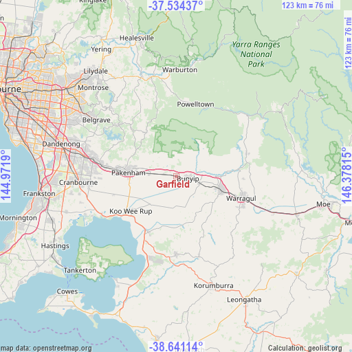
Garfield GPS coordinates[2]
38° 5' 23.46" South, 145° 40' 30.072" East
| Map corner | latitude | longitude |
|---|---|---|
| Upper-left | -37.53437°, | 144.9719° |
| Center: | -38.08985°, | 145.67502° |
| Lower-right: | -38.64114°, | 146.37815° |
| Map W x H: | 123.1×123.1 km | = 76.5×76.5mi |
| max Lat: | -10.58257° ⇑92.6% North |
| Garfield: | -38.08985° |
| min Lat: | ⇓7.4% South -43.31423° |
| min Long | Garfield | max Long |
| 113.53327° | 145.67502° | 153.61246° |
| W 41.2%⇐ | ⇒58.8% E |
Elevation
Elevation of Garfield is 50 m = 164 ft, and this is 72 m = 236 ft below average elevation for this country.
| Max E: |
1715 m = 5627 ft | 46.5% |
| Avg. | 122 m = 400 ft | |
| Garfield | 50 m = 164 ft | |
Min E: |
-2 m = -7 ft | 53.5% |
See also: Australia elevation on elevation.city.
Geographical zone
Garfield is located in South temperate zone (between Tropic of Capricorn and the Antarctic Circle). Distance of this Southern Tropic circle is 1629.3 km =1012.4 mi to North.| Distance of | km | miles | from Garfield |
|---|---|---|---|
| Equator | 4235.2 | 2631.6 | to North |
| Tropic Capricorn | 1629.3 | 1012.4 | to North |
| Antarctic Circle | 3166 | 1967.3 | to South |
| South Pole | 5771.9 | 3586.5 | to South |


Nearby cities:
15 places around Garfield: (largest is in red/bold)
• Buln Buln
22.6 km =14 mi,  92°
92°
• Bunyip
3.7 km =2.3 mi,  103°
103°
• Cockatoo
23.3 km =14.5 mi,  316°
316°
• Drouin
16.9 km =10.5 mi,  107°
107°
• Gembrook
18.5 km =11.5 mi,  325°
325°
• Koo-Wee-Rup
20.2 km =12.6 mi,  232°
232°
• Lang Lang
21.9 km =13.6 mi,  206°
206°
• Longwarry
8.6 km =5.3 mi, 107°
• Maryknoll
9.2 km =5.7 mi,  310°
310°
• Nar Nar Goon
9.2 km =5.7 mi,  275°
275°
• Nar Nar Goon North
12.5 km =7.8 mi, 310°
• Officer
23.5 km =14.6 mi, 278°
• Pakenham
17.7 km =11 mi, 277°
• Pakenham Upper
16.1 km =10 mi,  300°
300°
• Warragul
23.7 km =14.7 mi, 108°
Sources, notices
• [Note1] Compared only with cities in Australia existing in our database
• [Src1] Map data: © OpenStreetMap contributors (CC-BY-SA)
• [Src2] Other city data from geonames.org with taken over terms of usage.
• [Src3] Geographical zone / Annual Mean Temperature by Robert A. Rohde @ Wikipedia
