Mulwala geodata
Mulwala (New South Wales) is a populated place; located in Australia in Australia/Sydney (GMT+11) time zone. With population of 2,302 people, there are 2691 cities with bigger population in this country. Compared to other cities in Australia, 78.3% of cities are located further ↑North; 57.1% of cities are located further →East and 74.8% of cities have lower elevation than Mulwala. Note1


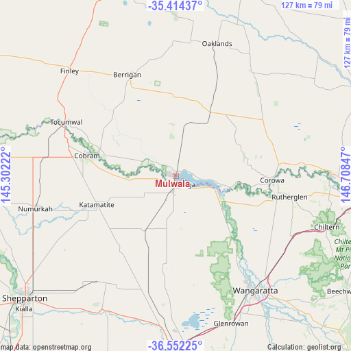
Mulwala GPS coordinates[2]
35° 59' 7.296" South, 146° 0' 19.224" East
| Map corner | latitude | longitude |
|---|---|---|
| Upper-left | -35.41437°, | 145.30222° |
| Center: | -35.98536°, | 146.00534° |
| Lower-right: | -36.55225°, | 146.70847° |
| Map W x H: | 126.5×126.5 km | = 78.6×78.6mi |
| max Lat: | -10.58257° ⇑78.3% North |
| Mulwala: | -35.98536° |
| min Lat: | ⇓21.7% South -43.31423° |
| min Long | Mulwala | max Long |
| 113.53327° | 146.00534° | 153.61246° |
| W 42.9%⇐ | ⇒57.1% E |
Elevation
Elevation of Mulwala is 129 m = 423 ft, and this is 7 m = 23 ft above average elevation for this country.
| Max E: |
1715 m = 5627 ft | 25.2% |
| Mulwala | 129 m 423 ft | |
| Avg. | 122 m = 400 ft | |
Min E: |
-2 m = -7 ft | 74.8% |
See also: Australia elevation on elevation.city.
Geographical zone
Mulwala is located in South temperate zone (between Tropic of Capricorn and the Antarctic Circle). Distance of this Southern Tropic circle is 1395.3 km =867 mi to North.| Distance of | km | miles | from Mulwala |
|---|---|---|---|
| Equator | 4001.2 | 2486.2 | to North |
| Tropic Capricorn | 1395.3 | 867 | to North |
| Antarctic Circle | 3400 | 2112.7 | to South |
| South Pole | 6005.9 | 3731.9 | to South |


Nearby cities:
15 places around Mulwala: (largest is in red/bold)
• Barooga
29.2 km =18.1 mi,  287°
287°
• Berrigan
40.3 km =25 mi,  334°
334°
• Cobram
33.6 km =20.9 mi,  282°
282°
• Corowa
34.2 km =21.3 mi,  92°
92°
• Invergordon
43 km =26.7 mi,  242°
242°
• Katunga
48.3 km =30 mi,  266°
266°
• Numurkah
51.9 km =32.2 mi,  257°
257°
• Rutherglen
41.8 km =26 mi,  100°
100°
• Strathmerton
47.9 km =29.8 mi, 278°
• Tocumwal
43.8 km =27.2 mi,  296°
296°
• Wahgunyah
35.4 km =22 mi, 94°
• Waldara
44.9 km =27.9 mi,  146°
146°
• Wangaratta
50.2 km =31.2 mi, 145°
• Yarrawonga
3.8 km =2.4 mi,  187°
187°
• Yarroweyah
40.9 km =25.4 mi, 279°
Sources, notices
• [Note1] Compared only with cities in Australia existing in our database
• [Src1] Map data: © OpenStreetMap contributors (CC-BY-SA)
• [Src2] Other city data from geonames.org with taken over terms of usage.
• [Src3] Geographical zone / Annual Mean Temperature by Robert A. Rohde @ Wikipedia
