Waldara geodata
Waldara (Victoria) is a section of populated place; located in Australia in Australia/Melbourne (GMT+11) time zone. With population of 587 people, there are 4607 cities with bigger population in this country. Compared to other cities in Australia, 79.5% of cities are located further ↑North; 56.1% of cities are located further →East and 77.4% of cities have lower elevation than Waldara. Note1


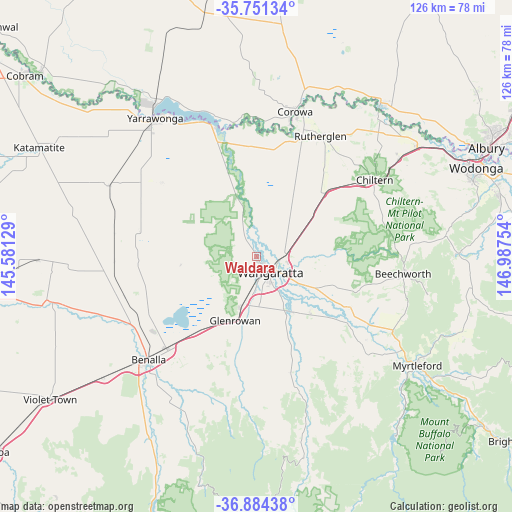
Waldara GPS coordinates[2]
36° 19' 11.712" South, 146° 17' 3.876" East
| Map corner | latitude | longitude |
|---|---|---|
| Upper-left | -35.75134°, | 145.58129° |
| Center: | -36.31992°, | 146.28441° |
| Lower-right: | -36.88438°, | 146.98754° |
| Map W x H: | 126×126 km | = 78.3×78.3mi |
| max Lat: | -10.58257° ⇑79.5% North |
| Waldara: | -36.31992° |
| min Lat: | ⇓20.5% South -43.31423° |
| min Long | Waldara | max Long |
| 113.53327° | 146.28441° | 153.61246° |
| W 43.9%⇐ | ⇒56.1% E |
Elevation
Elevation of Waldara is 151 m = 495 ft, and this is 29 m = 95 ft above average elevation for this country.
| Max E: |
1715 m = 5627 ft | 22.6% |
| Waldara | 151 m 495 ft | |
| Avg. | 122 m = 400 ft | |
Min E: |
-2 m = -7 ft | 77.4% |
See also: Australia elevation on elevation.city.
Geographical zone
Waldara is located in South temperate zone (between Tropic of Capricorn and the Antarctic Circle). Distance of this Southern Tropic circle is 1432.5 km =890.1 mi to North.| Distance of | km | miles | from Waldara |
|---|---|---|---|
| Equator | 4038.4 | 2509.3 | to North |
| Tropic Capricorn | 1432.5 | 890.1 | to North |
| Antarctic Circle | 3362.8 | 2089.5 | to South |
| South Pole | 5968.7 | 3708.8 | to South |


Nearby cities:
15 places around Waldara: (largest is in red/bold)
• Barnawartha
42.5 km =26.4 mi,  55°
55°
• Beechworth
36.2 km =22.5 mi,  96°
96°
• Benalla
37.2 km =23.1 mi,  226°
226°
• Chiltern
34.6 km =21.5 mi, 57°
• Corowa
37 km =23 mi,  14°
14°
• Glenrowan
16.8 km =10.4 mi,  198°
198°
• Howlong
48.9 km =30.4 mi,  39°
39°
• Milawa
18.4 km =11.4 mi,  133°
133°
• Mulwala
44.9 km =27.9 mi,  326°
326°
• Myrtleford
47.6 km =29.6 mi,  124°
124°
• Oxley
16.2 km =10.1 mi,  153°
153°
• Rutherglen
33.6 km =20.9 mi,  28°
28°
• Wahgunyah
35.7 km =22.2 mi,  16°
16°
• Wangaratta
5.4 km =3.4 mi,  142°
142°
• Yarrawonga
42.1 km =26.2 mi,  322°
322°
Sources, notices
• [Note1] Compared only with cities in Australia existing in our database
• [Src1] Map data: © OpenStreetMap contributors (CC-BY-SA)
• [Src2] Other city data from geonames.org with taken over terms of usage.
• [Src3] Geographical zone / Annual Mean Temperature by Robert A. Rohde @ Wikipedia
