Mossman geodata
Mossman (Queensland) is a populated place; located in Australia in Australia/Brisbane (GMT+10) time zone. With population of 2,084 people, there are 2840 cities with bigger population in this country. Compared to other cities in Australia, 97.8% of cities are located further ↓South; 60.7% of cities are located further →East and 81.9% of cities have higher elevation than Mossman. Note1


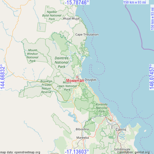
Mossman GPS coordinates[2]
16° 27' 46.512" South, 145° 22' 17.184" East
| Map corner | latitude | longitude |
|---|---|---|
| Upper-left | -15.78746°, | 144.66832° |
| Center: | -16.46292°, | 145.37144° |
| Lower-right: | -17.13603°, | 146.07457° |
| Map W x H: | 149.9×149.9 km | = 93.1×93.1mi |
| max Lat: | -10.58257° ⇑2.2% North |
| Mossman: | -16.46292° |
| min Lat: | ⇓97.8% South -43.31423° |
| min Long | Mossman | max Long |
| 113.53327° | 145.37144° | 153.61246° |
| W 39.3%⇐ | ⇒60.7% E |
Elevation
Elevation of Mossman is 14 m = 46 ft, and this is 108 m = 354 ft below average elevation for this country.
| Max E: |
1715 m = 5627 ft | 81.9% |
| Avg. | 122 m = 400 ft | |
| Mossman | 14 m = 46 ft | |
Min E: |
-2 m = -7 ft | 18.1% |
See also: Australia elevation on elevation.city.
Geographical zone
Mossman is located in South Torrid zone (between Equator and Tropic of Capricorn). Distance of this Southern Tropic circle is 775.4 km =481.8 mi to South.| Distance of | km | miles | from Mossman |
|---|---|---|---|
| Equator | 1830.5 | 1137.4 | to North |
| Tropic Capricorn | 775.4 | 481.8 | to South |
| Antarctic Circle | 5570.7 | 3461.5 | to South |
| South Pole | 8176.6 | 5080.7 | to South |


Nearby cities:
15 places around Mossman: (largest is in red/bold)
• Biboohra
45.2 km =28.1 mi,  171°
171°
• Clifton Beach
46.2 km =28.7 mi,  136°
136°
• Cooya Beach
4 km =2.5 mi,  65°
65°
• Craiglie
13.4 km =8.3 mi,  128°
128°
• Julatten
16.4 km =10.2 mi,  191°
191°
• Kewarra Beach
48.7 km =30.3 mi, 136°
• Koah
50.8 km =31.6 mi,  157°
157°
• Kuranda
48.8 km =30.3 mi, 144°
• Mowbray
15.8 km =9.8 mi, 133°
• Palm Cove
44.8 km =27.8 mi, 135°
• Port Douglas
10.5 km =6.5 mi,  102°
102°
• Speewah
54 km =33.6 mi,  151°
151°
• Trinity Beach
50.1 km =31.1 mi, 136°
• Trinity Park
52.2 km =32.4 mi, 137°
• Yorkeys Knob
53 km =32.9 mi, 135°
Sources, notices
• [Note1] Compared only with cities in Australia existing in our database
• [Src1] Map data: © OpenStreetMap contributors (CC-BY-SA)
• [Src2] Other city data from geonames.org with taken over terms of usage.
• [Src3] Geographical zone / Annual Mean Temperature by Robert A. Rohde @ Wikipedia
