Craiglie geodata
Craiglie (Queensland) is a populated place; located in Australia in Australia/Brisbane (GMT+10) time zone. With population of 1,098 people, there are 3698 cities with bigger population in this country. Compared to other cities in Australia, 97.8% of cities are located further ↓South; 59.9% of cities are located further →East and 91.8% of cities have higher elevation than Craiglie. Note1


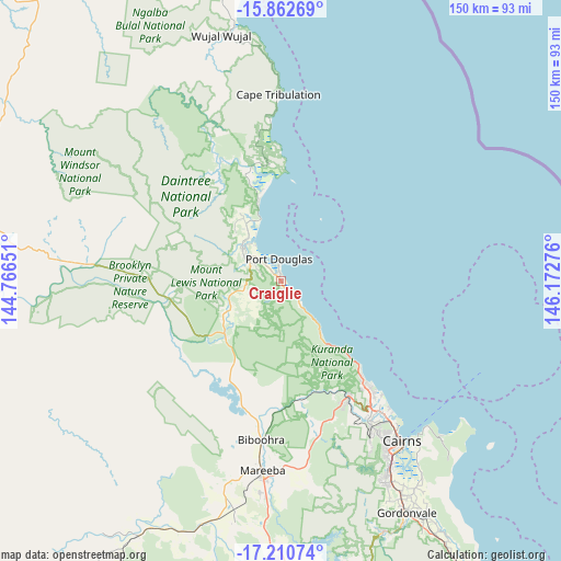
Craiglie GPS coordinates[2]
16° 32' 16.404" South, 145° 28' 10.668" East
| Map corner | latitude | longitude |
|---|---|---|
| Upper-left | -15.86269°, | 144.76651° |
| Center: | -16.53789°, | 145.46963° |
| Lower-right: | -17.21074°, | 146.17276° |
| Map W x H: | 149.9×149.9 km | = 93.1×93.1mi |
| max Lat: | -10.58257° ⇑2.2% North |
| Craiglie: | -16.53789° |
| min Lat: | ⇓97.8% South -43.31423° |
| min Long | Craiglie | max Long |
| 113.53327° | 145.46963° | 153.61246° |
| W 40.1%⇐ | ⇒59.9% E |
Elevation
Elevation of Craiglie is 8 m = 26 ft, and this is 114 m = 374 ft below average elevation for this country.
| Max E: |
1715 m = 5627 ft | 91.8% |
| Avg. | 122 m = 400 ft | |
| Craiglie | 8 m = 26 ft | |
Min E: |
-2 m = -7 ft | 8.2% |
See also: Australia elevation on elevation.city.
Geographical zone
Craiglie is located in South Torrid zone (between Equator and Tropic of Capricorn). Distance of this Southern Tropic circle is 767.1 km =476.7 mi to South.| Distance of | km | miles | from Craiglie |
|---|---|---|---|
| Equator | 1838.8 | 1142.6 | to North |
| Tropic Capricorn | 767.1 | 476.7 | to South |
| Antarctic Circle | 5562.3 | 3456.3 | to South |
| South Pole | 8168.2 | 5075.5 | to South |


Nearby cities:
15 places around Craiglie: (largest is in red/bold)
• Biboohra
36.5 km =22.7 mi,  185°
185°
• Clifton Beach
33 km =20.5 mi,  139°
139°
• Cooya Beach
12.1 km =7.5 mi,  325°
325°
• Julatten
15.7 km =9.8 mi,  240°
240°
• Kewarra Beach
35.5 km =22.1 mi, 139°
• Koah
39.6 km =24.6 mi,  167°
167°
• Kuranda
36.1 km =22.4 mi,  150°
150°
• Mossman
13.4 km =8.3 mi,  308°
308°
• Mowbray
2.7 km =1.7 mi,  157°
157°
• Palm Cove
31.6 km =19.6 mi, 138°
• Port Douglas
6 km =3.7 mi,  357°
357°
• Speewah
42 km =26.1 mi, 158°
• Trinity Beach
36.9 km =22.9 mi, 139°
• Trinity Park
39.1 km =24.3 mi, 139°
• Yorkeys Knob
39.8 km =24.7 mi, 137°
Sources, notices
• [Note1] Compared only with cities in Australia existing in our database
• [Src1] Map data: © OpenStreetMap contributors (CC-BY-SA)
• [Src2] Other city data from geonames.org with taken over terms of usage.
• [Src3] Geographical zone / Annual Mean Temperature by Robert A. Rohde @ Wikipedia
